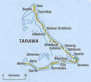
Bairiki
| Bairiki | ||
|---|---|---|
| Waters | Pacific Ocean | |
| Archipelago | Tarawa | |
| Geographical location | 1 ° 20 ′ 0 ″ N , 173 ° 0 ′ 0 ″ E | |
|
|
||
| length | 2.9 km | |
| width | 650 m | |
| surface | 51 ha | |
| Residents | 3218 (2015) 6310 inhabitants / km² |
|
| main place | Bairiki | |
| Bairiki is the southernmost of the dam-connected islands of South Tarawa | ||
Bairiki is an island and at the same time one of the most important places of the atoll Tarawa , the main atoll of the island state Kiribati . Most of the buildings of the government of Kiribati are located in Bairiki, which is why the place is also referred to as the capital of the island state by some, mainly German-speaking, sources. However, the capital is the South Tarawa district , which includes Bairiki and the neighboring islands.
In Bairiki, next to the post office and telephone office, there is a small port - the main port of the island state is on the neighboring island of Betio - and a campus of the University of the South Pacific with 3,000 students.
Including the Bairiki Causeway (road embankment, 3.6 hectares) and the shipyard with pier (1.4 hectares), the island has an area of 51.0 hectares . In the east is the island of Nanikai , in the west Betio . The islands are connected by a causeway .
| Population figures in Bairiki | |||
| 1978 Census | 2005 census | Census 2015 | |
|---|---|---|---|
| Total | 1.956 | 2,766 | 3,218 |
Individual evidence
- ↑ USP Kiribati Campus (accessed December 26, 2017)
- ^ Report of the 1978 Census of Population and Housing. Republic of Kiribati 1980, Vol. 1, p. 7
- ↑ Kiribati 2005 Census of Population and Housing (accessed March 28, 2010)
- ↑ 2015 Population and Housing Census. Volume 1. Bairiki, September 2016. (accessed December 26, 2017)

