Date line

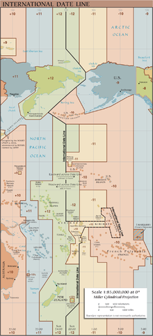
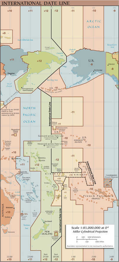
The date line runs between the two poles of the earth through the Pacific Ocean near 180 degrees of longitude . If you cross the date line, you enter a time zone with a different calendar date : If you cross the date line with an eastward exchange rate, you get to the previous calendar day , and if you go the other way, the next calendar day . Residents on both sides of the date line do not have the same calendar date. This is one calendar day higher on the western side than on the eastern side.
Need for a date line
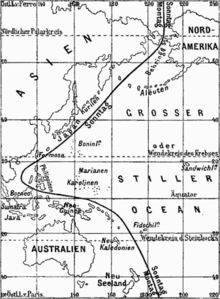
The date always changes (once) on the meridian where it is currently 24: 00/00: 00 (midnight line). This "natural" (first) change of date moves around the earth with the opposite point of the sun once a day. Inevitably, there must be a second change of date so that the earth can be divided into two areas with the old (yesterday or today or ...) and the new date (today or tomorrow or ...) (see two sketches opposite). This other change of date takes place by convention on the earth's fixed date line, which is approximately 180 degrees longitude. The fact that the dividing line falls between the two large continents Asia and America, namely at their most remote and least populated ends, makes this choice even more appropriate.

In one place, when you pass the midnight line, yesterday becomes today .
Times in solar time
In principle, any degree of longitude could be the date line. The internationally agreed current location in the Pacific Ocean was chosen because only a few people live there. They were expected to have neighbors who live on the other side of the date line always (also during the day) on a different date.
Effects of crossing the date line
The following considerations do not depend on the fact that the usual use of the time today is no longer directly linked to the degree of longitude ( solar time , true local time), but that a zone time is used within intervals between degrees of longitude . To avoid secondary complications, do not consider passages of the date line in the hour before and after midnight (or think in real local time).
If you travel around the earth in an easterly direction (towards the sun), you usually have to advance the clock by 1 hour each time the time zone changes . If the date were not set back at the date line, one would have "generated" 24 hours of time (one day) after one orbit around the earth, which is basically not possible. The "repayment" of time when traveling in the opposite direction is also out of the question. The fallacy is based on the fact that the travel days are no longer 24 hours long when the clock is adjusted. By introducing them they become shorter, by putting them back they become longer.
When crossing the date line, a journey through all time zones in the opposite direction around the whole earth is simulated. It is helpful to think that the date to be assumed is that which a traveler brings with him who has traveled in the opposite direction to the date line. The traveler westward (with the sun) has continually set his clock back. His date is one day earlier than that of the eastbound traveler.
If one looks at a self-contained area of the earth , it is easy to set a uniform date scale for this area. If you do not travel too far in a westerly direction, you have to reduce the time accordingly; if you travel in an easterly direction, you have to increase the time accordingly.
However, looking at the earth as a whole, there is a problem that each point can be reached by traveling east as well as traveling west. It is true that both clocks that were brought along and that were correctly adjusted on the way would show the same time, but one would have experienced midnight more often on one of the trips (from west to east), so that another day would result. So there would be no clearly defined date for the destination point. If you circle the earth completely, you would even have a date for the starting point - depending on the direction - which is one day different from the date that remained at the starting point.
This ambiguity can only be resolved by arbitrarily defining a limit that must not be exceeded when calculating the date and time based on the difference in length, or when crossing a day must be added or removed, as if one were in the other direction traveled around the earth.
historical development

The first to be confronted with the phenomenon in practice were the seafarers under Ferdinand Magellan , who successfully circumnavigated the world from 1519 to 1522. Since they were not yet familiar with the phenomenon, there was great confusion when the few survivors of the company returned to Spain and, despite careful counting based on the logbook entries, named a date that was one day different than the ones at home.
As a result, a date line was created, but to the international agreement on the meridian of Greenwich as the prime meridian had been in 1884 still rather vague and arbitrary and performed differently from any maritime nation. The inner connection between the prime meridian (every seafaring nation had its own) and its direct counterpart - the date line - had never been established by anyone. The Spaniards had led the date line west of the Philippines because they had conquered and colonized it from Mexico and cultivated it from there. When the American colonies became independent from Spain and the Philippines' trade relations with its Asian neighbors had become more important, Spain adopted the Asian date for the Philippine colony at the turn of 1844/45 and moved the date line east to the Pacific.
In contrast to the map shown, Alaska was on the Asian side as long as it belonged to Russia , i.e. west of the date line. It was not until 1867 with the sale of Alaska to the United States of America that it made its way to the American (eastern) side of the date line. So there was a direct change of date from October 6th ( Julian calendar ) to October 18th, 1867 ( Gregorian calendar ). The difference was therefore only 11 days due to the shift in the date line instead of the 12-day difference between the two calendars at that time.
Following the agreement on the Greenwich Meridian as the prime meridian, the Russian diplomat Karl von Struve defined the 180th degree of longitude strictly as the date line. It is a straight line (a degree of longitude), which was also beneficial to the agreement following the global introduction of time zones. Like its vague predecessors, it lies in the Pacific and essentially does not divide any contiguous land mass. The already economically closely networked and at the time most productive industrial regions in Europe and North America remained untouched by the date line as before. The initiative of the “inventor of the world time” Sandford Fleming ultimately led to the Greenwich meridian. His preferred "counter-arch" led to the date line, the function of which, strangely enough, he never commented on.
Today's course of the date line
General
The 180th degree of longitude runs mainly through water, which is why it is also suitable as a date line. Where this longitude crosses a country or divides a group of islands that belong together politically, the date line has been adjusted over time. Today the date line is nowhere across land.
Wrangel Island and Chukchi Peninsula (shift to approx. 169 ° West)
The northernmost point where the 180th longitude cross land is leading to Russia is part of Wrangel Island , south then the Chukchi Peninsula . Therefore, the date line was laid here in an eastward direction up to around 169 ° W through the Bering Strait . The UTC + 12 time zone has been extended to the Bering Strait.
"Divided" archipelagos and Samoa

Where the 180th degree of longitude crosses archipelagos, their political affiliation was taken into account when determining the date line. As this has changed over the years, the date line has also undergone various changes.
Diomedes Islands (shift to approx. 169 ° West)
The date line runs between the two Diomedes Islands that are in sight of each other in the Bering Strait . The western Ratmanov Island belongs to Russia (Russian Остров Ратманова ostrow Ratmanowa, older name Imaqliq), the eastern Little Diomede Island belongs to Alaska.
Aleutian Islands (shift to approx. 171 ° East)
The Aleutian Islands - territory of the United States - lie on both sides of the 180th degree of longitude, but their western islands belong to UTC-10 . So here the date line is bulging to the west.
Kiribati (shift to approx. 150 ° West)
For a long time, the Micronesian island state of Kiribati , whose tiny islands stretch over almost 5000 km in an east-west direction in the Pacific, was divided by the date line. In this one territory, the day had two calendar dates, which was not a big problem at first. In the course of the state's development, however, a date had to be set. Kiribati chose to be completely west of the date line, which took effect on January 1, 1995. This was the largest shift in the date line to date.
The adjustment meant that the easternmost island of Kiribati was officially the first part of the world to welcome the year 2000. Advertising pregnant this island was therefore (as in German "Millennium Iceland" Millennium Island ) renamed.
In the east of Kiribati, the date line has a bulge to the north and south. Here there are short places where the otherwise usual date change for east / west and west / east trips has to be reversed. The alignment of the date line initiated by Kiribati has other curious connections as well:
- Instead of the previous two, three different calendar dates can occur on Earth at the same time.
- There are places on the date line where the date changes not by one but by two calendar days when crossing at certain times.
Samoa (shift to approx. 171 ° West)
The island state of (Western) Samoa moved to the eastern side of the date line in 1892 due to the influence of American traders. The day of the changeover was July 4th (the anniversary of American independence), which means that Samoa took place twice. In 2011 the change took place back to the western side, since trade relations with New Zealand, Australia and Asia were meanwhile more important than those with America. December 30, 2011 was skipped, also on the Tokelau archipelago, 500 km to the north . The neighboring American Samoa remained on the "American" eastern side.
New Zealand (shift to approx. 172.5 ° West)
Since the colonial power of that time England counted some islands east of the two main islands and east of the 180th degree of longitude to New Zealand (especially to mention the Chatham Islands ), the 180th degree of longitude was deviated here to the east. The relocation continues to this day, as these islands also currently belong to New Zealand.
Antarctic
In the uninhabited Antarctic, the time zones are generally based on the time zones of the nations of the respective research camps or on the closest supply country. For example, the American Amundsen-Scott South Pole Station uses the same time zone as New Zealand, UTC + 12 .
According to this arbitrary assignment of the time zones to the camps scattered across the Antarctic continent, no simple, linear date line can be defined.
The current dates and times near the date line
The map on the right shows the time and date relationships near the date line on August 26, 2020 at 3:13 p.m. UTC .
Every day from 10:00 UTC up to and including 11:00 UTC on Earth, as already described in the Kiribati chapter , there are three different calendar dates at the same time. On the map on the right, the two points at which the three dates coincide locally during an hour of the day are marked in red. If one counts the time zone UTC − 12 (areas marked in green east of the date line), in which there are bodies of water and the two uninhabited US Baker and Howland Islands , the state even lasts until 12:00 UTC not included.
Motto in seafaring
For the date to be entered in the logbook when crossing the date line, the following motto helps:
- From east to west hold the date,
from west to east let go of the date.
East and west do not refer to the direction in which one is traveling, but to the western or eastern hemisphere as seen from the prime meridian, i.e. the areas of western or eastern longitude.
After crossing the date line with an easterly course (from east to west) , one initially remains at the same date. Switching back takes place with a delay in that the next day or the next page of the logbook is only given the same date as the day before (keep the date fixed) . In the case of western courses (from west to east) , the response is only made the next day by starting the new page in the logbook with the next but one date (let go of the date) .
The date line in literature
In the novel In 80 Days Around the World by Jules Verne , which has been filmed several times , the protagonist Phileas Fogg forgets to set the date back one day while crossing the date line in an easterly direction, and only discovers this mistake at the end of the trip in London. This fact leads to an exciting outcome of the bet to circumnavigate the earth in a maximum of 80 days.
Arthur C. Clarke's science fiction short story The Siren Goddess (Original title: Trouble with Time , 1960) is about the fact that the theft of the exhibit from a museum on Mars fails because the corresponding city Meridian City is exactly on the local date line and the burglar makes a related error: At the time of the break-in, it is not Sunday, but Saturday, and the museum is open.
Umberto Eco's novel The Island of the previous day deals with a partly mysticistic examination of the phenomenon of longitudes, especially the 180.
In the first appeared in 1991 History The Iceland at the edge of time (dt. The island at the time ) of Disney cartoonist Don Rosa argue Scrooge McDuck and Mac Moneysac a short time before by volcanism exactly on the date line of golden magma formed island. Moneysac reached the island in the morning. Dagobert only arrived on the island in the afternoon, but was able to raise his claim to the island a day earlier than Moneysac because he set his " claim " on the east side . Moneysac did that a few hours before him on the west side and was still late because that side already had the next calendar day. Scrooge's side still had the previous calendar day, and so his registration was formally a calendar day earlier than Moneysac's.
Web links
- Thoughts on the date line, prime meridian and time zones
- Telepolis : where does the first sunrise of the new millennium take place? May 24, 1999 - The date line in terms of tourism at the turn of the year
- A History of the International Date Line
References and comments
- ^ Siegfried Schoppe: Heinrich the Navigator, Columbus and Magellan: Planning, Trial and Error, p. 96
- ^ Clark Blaise: The Taming of Time , S. Fischer 2001, ISBN 3-10-007109-3 , p. 265
- ↑ Winfried Görke: “Date and Calendar: From Antiquity to the Present”, p. 9
- ^ Explanatory Supplement to the Astronomical Ephemeris . 1961, p. 414 .
- ↑ Clark Blaise: The Taming of Time. S. Fischer 2001, ISBN 3-10-007109-3 , p. 266.
- ^ Clark Blaise: The Taming of Time , S. Fischer 2001, ISBN 3-10-007109-3 , p. 263
- ↑ Thoughts on the date line, prime meridian and time zones : cf. 10.5. Places on the date line where the date changes in reverse
- ↑ Thoughts on the date line, prime meridian and time zones : cf. 10.3. What is the maximum number of different calendar dates that can exist simultaneously in different places on earth?
- ↑ Thoughts on the date line, prime meridian and time zones : cf. 10.4. When crossing the date line, is it possible to get into an area where the date is two days instead of one day?
- ↑ Samoa cancels December 30 , orf.at, December 26, 2011
- ↑ South Sea State of Samoa: December 30th? Canceled this year!
- ^ Announcement from Borneo Post online
- ↑ Volkssternwarte Recklinghausen: Astronomical Navigation, p. 5 (PDF; 818 kB)
- ↑ See Archives of Time : Around the World in 79 Days , Lecture by Jules Verne, 1873
- ↑ In the end, however, Dagobert is also the duped, because his Pacific tour guide had already knocked the anchor of their boat into the island floor when it landed. This stake was considered a claim stake, and the guide and his poor tribe had become the owners of the island.

