Geology of Banaba
The geology of Banaba is characterized by an isolated seamount that sits on the southeastern Nauru Basin . As an upscale atoll , the island has a coral reef at its tip . Banaba had very rich phosphate deposits , but these are now as good as exhausted.
Geological framework
Banaba is isolated in the southeastern Nauru Basin and is therefore part of the western Pacific Ocean . The neighboring Nauru is 298 kilometers away in a west-northwest direction. It is 440 kilometers to Tarawa ( Kiribati ) in the northeast.
The seamount is based at a depth of around 4500 meters. The magnetic anomaly M 13 runs below it in an east-northeast direction , which is dated 138.5 million years ago in the Valanginian . The oceanic crust is not exposed here, rather it is covered by basaltic lava flows and dyke intrusions that are up to 4,300 meters thick. About 500 meters of deep sea sediments are also lying on top.
The flood basalts and dike intrusions are similar to MORB and are genetically related to the neighboring flood basalts of the huge Ontong-Java plateau , which were formed during the Aptian around 120 million years. But they are not absolutely pure MORB, but have, in particular in its isotopic composition geochemical variations towards ocean island basalts ( English ocean Iceland basalt or OIB ) on.
To the south, the sea floor rises sharply to the eastern spur of the Ontong Java plateau, around 300 kilometers away, which girdles the Nauru basin in the west and south. The Ontong-Java Plateau is a huge Magmatic Greater Province (English Large Igneous Province or LIP for short ), which lies in only 3000 to 2000 meters water depth. The Nauru Basin is bounded in the north and east by the seamount chain of the Marshall and Gilbert Islands ( Marshall-Gilbert-Seamount-Chain ).
description
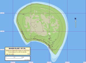
The roughly horseshoe-shaped island has a diameter of around 3.5 kilometers, but measures only 2.8 kilometers in a northeast-southwest direction. Its surface is 6.29 square kilometers. Its highest point reaches 81 meters above sea level. The island generally drops quite steeply to the sea up to the 500 meter Isobathe , and then ends relatively flat at an angle of about 20 ° into the Nauru Basin. The 2000 meter Isobathe is 5 kilometers away.
When the seamount reached sea level, a belt of reefs could establish itself on it. The reef belt, in turn, was raised further by subsequent tectonic movements. It is assumed that the uplift of Banaba is due to an internal deformation of the Pacific plate , which was triggered by collisions on the Ontong-Java plateau. The result of the elevation was karstification , dolomitization and the formation of radial and concentric breaks in the former atoll as well as the growth of a living Holocene reef, which now girdles Banaba and makes access to the island more difficult for ships.
Mass movements
Banaba owes its strange shape, which clearly differs from a circular shape, to a huge submarine landslide in Home Bay in the south of the island. The landslide created a 1000 to 1500 meter wide and 400 meter deep underwater canyon with very steep side walls. It is almost 5 kilometers long, strikes northeast-southwest and can be followed up to the 2000 meter Isobathe. This mass movement is likely to have occurred in the Holocene.
In addition to the huge landslide in Home Bay , which probably triggered a tsunami , other secondary mass movements can be observed on the seamount, recognizable by breaklines, furrowed groove systems and sediment bulges.
Phosphate degradation
Together with Makatea and Nauru , Banaba is one of the three large phosphate islands in the Pacific. Since its emergence, the island has been used by sea birds as a nesting and breeding site. Their phosphate-rich guano , several meters thick in places, collected in depressions in the reef limestone . Since the deposits were on the surface of the reef, they could be extracted in the open pit . Mining began in 1900 and was discontinued in 1979 due to unprofitability. In these 80 years a total of around 20 million tons of phosphate were extracted.
The open-cast mine caused major environmental damage, particularly through the removal of the soil layer and the removal of the traditional vegetation.
Individual evidence
- ↑ Kimihiro Mochizuki et al: Massive Early Cretaceous volcanic activity in the Nauru Basin related to emplacement of the Ontong Java Plateau . In: Geochemistry, Geophysics, Geosystems . Volume 6, No. 10 , 2005, pp. 1-19 , doi : 10.1029 / 2004GC000867 .
- ↑ Kroenke, LW, Wessel, P. and Sterling, A .: Motion of the Ontong Java Plateau in the hot-spot frame of reference: 122 Ma - present . In: Fitton, H. et al., Origin and evolution of the Ontong Java Plateau (Ed.): Geological Society, special publication . vol. 229. Geological Society, London 2004, pp. 9-20 .
