Honiara
| Honiara | ||
|---|---|---|
|
|
||
| Coordinates | 9 ° 26 ′ 0 ″ S , 159 ° 57 ′ 0 ″ E | |

|
||
| Symbols | ||
|
||
| Basic data | ||
| Country | Solomon Islands | |
| Honiara | ||
| ISO 3166-2 | SB-CT | |
| surface | 22 km² | |
| Residents | 84,520 (2017) | |
| density | 3,841.8 Ew. / km² | |
|
Mendana Avenue, Honiara's main shopping street
|
||
Honiara [dt. hoʊnɪˈɑːrə ] is the capital of the independent island state of the Solomon Islands in the southwestern Pacific Ocean .
Geographical location
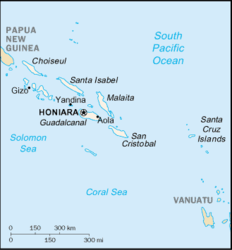
Honiara is a port city on the north coast of the island of Guadalcanal . The place is located at the mouth of the Matanika River . Honiara is also the capital of Guadalcanal Province , although the capital district is not part of the province.
City structure
Honiara is divided into twelve wards , which are grouped into three electoral districts (constituencies). Of the wards , six are east of the Matanika River and six are west, with the western bank forming the border. The city center is west of the Matanika River. The central district is Cruz with only 232 inhabitants (2009), with numerous administrative buildings and shops. China Town , a neighborhood on the east bank of the Matanika River, is part of the Mataniko wards . On the land side, the capital district borders on all sides with the Tandai district of the Guadalcanal province. The individual wards , from west to east, grouped according to electoral districts , with population figures from the census of November 16, 2009:
|
Cityscape
Honiara extends mainly around 12 km long along a narrow coastal strip at a harbor bay . Numerous houses of the lower class of the population were built on the wooded slopes that close the narrow coastal strip to the south. Mendana Avenue, named after the discoverer of the Solomon Islands, is the main thoroughfare and main commercial street that continues east of the river as the Kukum Highway. The business center is broken up by several small lawns with monuments and green spaces, of which the Police Memorial Park is one of the largest. There are no traffic lights in Honiara. In most cases you will look in vain for street signs or house numbers.
history
Before Honiara was founded, a bloody battle of World War II raged here: the Battle of Guadalcanal . Today's harbor bay of the city got its name Ironbottom Sound (German: Eisengrund Bay ) after the 50 or so warships that were sunk here during the fighting between the Americans and the Japanese. After the island was taken by the Americans, a military base was built here in 1943, from which the new city of Honiara developed from 1945, benefiting from the existing infrastructure. More and more people settled on the coast between today's districts of Kukum and Point Cruz. Since the previous capital of the Solomon Islands, Tulagi on the island of the same name, was almost completely destroyed in the war, the British declared Honiara instead of Tulagi the seat of government in order to be able to use the buildings of the military base for their purposes. Towards the end of the 1950s, the city had 3,550 inhabitants. When the Solomon Islands became independent on July 7, 1978, Honiara remained the seat of government. In April 2006 riots broke out in the course of which numerous Chinese shops and houses were looted and set on fire - especially on April 18, which went down in the history of the city as "Black Tuesday". As around 400 people were left homeless and 90% of Honiara's Chinatown was destroyed, many Honiara's residents of Asian descent subsequently left the country.
climate
The climate is tropical , the average daily temperature is a constant 28 degrees Celsius , the water temperatures between 26 and 29 degrees. More humid periods are mainly between November and April, but these are not very pronounced. The average amount of precipitation per year is 2000 mm and thus somewhat lower than the average for the Solomon Islands (3000 mm). For comparison: the average precipitation in Germany is 760 mm.
Climate table
| Honiara | ||||||||||||||||||||||||||||||||||||||||||||||||
|---|---|---|---|---|---|---|---|---|---|---|---|---|---|---|---|---|---|---|---|---|---|---|---|---|---|---|---|---|---|---|---|---|---|---|---|---|---|---|---|---|---|---|---|---|---|---|---|---|
| Climate diagram | ||||||||||||||||||||||||||||||||||||||||||||||||
| ||||||||||||||||||||||||||||||||||||||||||||||||
|
Average monthly temperatures and rainfall for Honiara
Source: wetterkontor.de
|
|||||||||||||||||||||||||||||||||||||||||||||||||||||||||||||||||||||||||||||||||||||||||||||||||||||||||||||||||||||||||||||||||||||||||||||||||||||||||||||||||||||
Economy and Transport
The international airport Honiara International Airport (until November 2003 Henderson Airfield ) is about 10 kilometers east of the city. It replaced the American airfield from World War II . From the port there are boat connections to most of the other islands of the Solomon Islands. Occasionally it is also used by cruise ships. Honiara is the headquarters of Solomon Airlines and the South Pacific Forum Fisheries Agency . Most buses stop in front of the market hall, but do not run according to a fixed timetable. When the market ends in the early afternoon, there is the last chance to travel from Honiara to the surrounding villages.
Industry can be found in Honiara in the form of several beverage factories, u. a. a brewery and a biscuit factory. Export goods that are mainly transported by sea are coconuts, copra and fish. The main trading partners are Malaysia , Japan , South Korea and Taiwan . Next to many houses there are beds or tiny fields on which vegetables and fruit are grown for personal use as part of subsistence farming .
administration
The Solomon Islands are divided into ten different governorates (corresponds to the German federal states); one of them is Honiara which is administered by the Honiara City Council . This makes it the smallest governorate in terms of area; the other nine manage the state's 997 islands.
After violent unrest in 2000, the administration was reorganized and made operational under the direction of Australian teams. International organizations, including European ones, supported the reconstruction in a wide variety of humanitarian areas. The City Council is housed in several buildings on the eastern edge of the city center.
Religions
The main religion of the island is Christianity (with 96% of all believers); Honiara has been an archdiocese since December 22, 1978 .
Attractions
The parliament building, a construction from 1993 in the form of classic palm frond rotunda, offers the 50 parliamentarians of the island state a comfortable working environment. The building can be viewed by arrangement with the guards; However, there are no official sightseeing tours. Another government building worth seeing is the Department of the Interior just west of downtown on Mendana Avenue, named Melanesia Pacific House . The German word "house" is used in Papua New Guinea and the Solomon Islands to designate an important building, with the German and not the English spelling "house" being used. The use of the German spelling is explained by the fact that part of Papua New Guinea was a German colony until 1918 and the northern islands of the Solomon Islands until 1899, and that some German terms found their way into the languages of Melanesia as loan words. Some restaurants in Honiara also use the German spelling "Haus" in their names to this day.
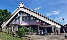
Most of the distinctive buildings are on Mendana Avenue, Honiara's main thoroughfare and shopping street. The lively CentralMarket market hall is also located here . The National Museum, founded in 1970, contains, among other things, collections on dance, body paintings and traditional weapons of the Solomon Islands. The Catholic Holy Cross Cathedral was built in 1975-78. Other prominent buildings are the City Council , the market hall, the Anglican St. Barnabas Cathedral and the octagonal Wesley United Church. The Anglican All Saints Church , the original cathedral of Honiara, received its present form in 1971. In front of it, under a protective roof, there is a large drum with which the believers are called to worship.
During the riots in 2006, the previously known Chinatown of Honiara on the Mataniko River was 90% destroyed, so that hardly anything in the city reminds of it. One of the few remaining Chinese buildings is the Hong Kong Palace , a now closed restaurant on Hibiscus Avenue, outside the former Chinatown.
The botanical garden in the west of the city is known for its large variety of orchids . The collection of tropical bush and rainforest plants is also worth seeing. To the east of the city there are several monuments commemorating the battles of World War II, e.g. B. the 2017 built Bloody Ridge Memorial . The Bloody Ridge chain of hills on the southern edge of Honiara, where a particularly bloody battle took place from September 12 to 14, 1942, with around 40,000 dead, was declared a national park in 2017.
Schools and universities
- Honiara International School in Honiara (also for non-locals); up to 6th grade (grade 6); Tuition according to the curriculum of Queensland / Australia (since 2003; before that to New South Wales / Australia); about 150 students, about half of them foreigners.
- The University of the South Pacific campus is to the east of the city. Several of the buildings were built in the traditional Solomon Islands style, with stakes and steles decorated with carvings typical of the Solomon Islands.
life quality
- Unreliable power supply . Emergency power generators are common.
- The drinking water supply is inadequate. Many people in the Solomon Islands have no access to clean drinking water and make do with rainwater cisterns on roofs.
- One of the most common diseases in the Solomon Islands is malaria .
- The garbage collection is inadequate. The environmental awareness of many people in the Solomon Islands is not yet very pronounced.
- Medical care is inadequate. There are only a few doctors with private practices. The main hospital in the Solomon Islands is east of downtown on the Kukum Highway, but it only offers basic medical care. With regard to dental care, the few dentists only provide basic care; Treatment by specialists can only be carried out abroad.
Sports
All games of the highest soccer league, the Telekom S-League (hosted by the Solomon Islands Football Federation ), take place in the Lawson-Tama Stadium. In addition, the Honiara Football Association organizes the HFA League, which is divided into the Premier League, Division One and Division Two. They are usually organized several weeks before the start of the S-League. The matches will take place at Lawson Tama, AE Soccer Ground Ranadi and King George VI Ground.
Web links
- General information from the FFA in English ( Memento from September 21, 2003 in the Internet Archive )
- Solomon Islands Historical Encyclopaedia 1893–1978: Honiara
Individual evidence
- ↑ Statoids: Provinces of Solomon Islands
- ^ Honiara City Council: HCC Ward Map
- ↑ https://law.uq.edu.au/files/27216/UQChapter3British%20Solomon%20Islands%20Protectorate.pdf
- ^ Mark Honan: Solomon Islands , p. 92. Hawthorn 1997
- ↑ http://www.solomonencyclopaedia.net/biogs/E000133b.htm
- ↑ http://www.methodist.org.nz/mission_and_ecumenical/archived_newsletters/newsletters_2006
- ↑ http://news.bbc.co.uk/2/hi/asia-pacific/4930994.stm
- ↑ Bernd Helms: Pacific Islands , p. 25. Munich 1981.
- ^ Mark Honan: Solomon Islands , p. 95. Hawthorn 1997
- ↑ http://www.solomonencyclopaedia.net/biogs/E000008b.htm
- ↑ https://marineraiderassociation.org/events/memorial-visitations/
- ↑ https://www.rnz.co.nz/international/pacific-news/336795/solomons-declare-bloody-ridge-a-national-park


