Guadalcanal (island)
| Guadalcanal | |
|---|---|
|
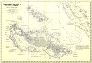
Map of the island, with historical districts: Vaturanga, Tasimboko, Galaga, Maarau, Kolina, Veuru |
|
| Waters | Solomon Lake |
| Archipelago | Solomon Islands |
| Geographical location | 9 ° 37 ′ S , 160 ° 11 ′ E |
| surface | 5 302 km² |
| Highest elevation |
Popomanaseu 2335 m |
| Residents | 109,382 (1999) 21 inhabitants / km² |
| main place | Honiara |
| Topographic map | |
Guadalcanal (locally also Isatabu , formerly Guadalcanar ) is a Pacific island of the Solomon Islands and the main island of the province of the same name in the island republic of Solomon Islands . Honiara , the capital of the Solomon Islands, is located on Guadalcanal . With 5,302 km² it is the largest island in the Solomon Islands. The population was 109,382 in 1999, of which 49,107 lived in Honiara (separate capital district, no longer part of the Guadalcanal province since July 1983).
The highest mountain in the Solomon Islands, the 2,335 m high Popomanaseu, is located on Guadalcanal .
history
The island was discovered in 1568 by a Spanish expedition led by Alvaro de Mendaña de Neyra . His officer Pedro de Ortega named it after his birthplace Guadalcanal in Spain.
In 1885 the German Empire and England delimited their spheres of interest in the South Seas. Starting from New Guinea , a dividing line was drawn at the 8th degree south latitude. Guadalcanal was south of it and fell into the English sphere. In 1893 Great Britain established a protectorate over the southern Solomon Islands. With this Guadalcanal also came under international law to the British Empire.
In 1896 the Austrian gunboat SMS Albatros was on the island with the search expedition of the geologist Baron Heinrich Foullon von Norbeeck (1850–1896), the possibility of exploiting nickel ore was explored. The company failed. Foullon von Norbeek and three sailors were ambushed and killed by locals.
In 1901, sailors of the Austro-Hungarian Navy from the small cruiser SMS Leopard erected a stone cross for their marines who had died five years earlier on Guadalcanal. In 1919 the island became an Australian mandate. The administrative center ( Government Station ) was Aola on the eastern north coast, 75 kilometers (58 as the crow flies ) east of the future capital Honiara. The national capital Honiara only emerged from a US military base from 1945.
The island became famous for the Battle of Guadalcanal in World War II , in which Japanese and US troops fought fierce battles.
After gaining independence in 1978, Guadalcanal became an island of immigration. In particular, residents of the neighboring island of Malaita moved to Guadalcanal by the tens of thousands. At the end of the 1990s, as a result of an economic crisis, there were frequent violent attacks by the Guadalcanalese on the immigrant Malaitans.
The Isatabu Freedom Movement (IFM) was a group that took up the armed struggle against the Malaitans and the police. They wanted to free the island from the immigrants. The Malaita Eagle Force (MEF) formed as a countermovement . It succeeded in June 2000, the government overthrow and the Civil War to intensify even further. As a result, the fighting has now expanded and hundreds of people lost their lives. Many Malaitans fled back to their home island, and the MEF drove thousands of Guadalcanalese from their ancestral villages.
It was only through mediation by the Australian government that the armed conflict was ended when a peace agreement, the so-called Townsville Peace Agreement , was concluded in October 2000 .
economy
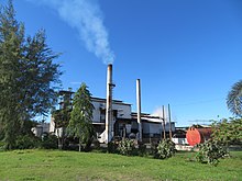
The place Tetere about 25 km east of Honiara is of great importance for the economy of the Solomon Islands, because in 1976 extensive plantations of oil palms were established in its area, and the processing of the fruits for export takes place on site in Tetere.
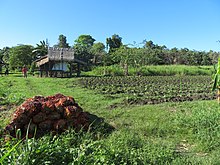
As in general in the Solomon Islands, many people on Guadalcanal also make a living from subsistence farming and grow food for self-sufficiency in small fields around their houses. What the families do not consume themselves is sold at the nearest market - e.g. B. in Tetere - or sold at small stalls on the street.
The infrastructure on Guadalcanal is not yet sufficiently developed. One of the few asphalt roads is the road from Honiara to Lambi (58 km) on the north coast of the island of Guadanalcanal in the west of the island and the road to Aola (75 km) in the east via Tetere.
Others
August 1st is the provincial day of Guadalcanal, which is celebrated with solemnity. If it falls on a Sunday, the following Monday is off work.
See also
Individual evidence
- ↑ Latest country and ethnology: A geographical reading book. Volume sixteenth: Australia . Publishing house of the geographical institute, Weimar 1814, p. 282.
- ^ Statoids: Provinces of the Solomon Islands
- ↑ Mark Honan: Solomon Islands , p. 109. Hawthorn 1997
- ↑ Südsee , p. 41. Nelles Verlag, Munich 2011
Web links
- Fatal search for nickel ore in the Wiener Zeitung by Ilona Gälzer


