
Duff Islands
| Duff Islands | ||
|---|---|---|
 |
||
| Waters | Coral sea | |
| archipelago | Santa Cruz Islands | |
| Geographical location | 9 ° 51 ′ S , 167 ° 9 ′ E | |
|
||
| Number of islands | 11 | |
| Main island | Taumako | |
| Total land area | 14 km² | |
| Residents | 511 (2009) | |
.png) |
||

.jpg)
The Duff Islands (other name: Taumako Islands , also Wilson's Islands in older maps ) are a group of eleven small islands in the eastern Pacific Ocean that are geographically part of the Santa Cruz Islands . Politically, they belong to the island state of the Solomon Islands and are located in the southernmost province of Temotu .
geography
The archipelago includes the following islands:
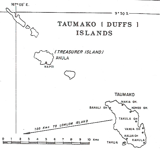
- Taumako (formerly Disappointment Island ) with the secondary islands of Tahua in the southwest and Tohua in the southeast
- the Bass Islands at the southern end of the island chain: Lua, Kaa and Loreva
- the Treasurers Islands at the northern end: Tuleki (Anula), Elingi (Obelisk Island), Te Ako, Lakao and Ulaka
Geographically, the submarine Hallie Jackson Reef to the west of Lakao is often counted among the Duff Islands, although it is 45 km away from the island chain and does not rise above the sea surface.
The islands together have a land area of around 14 km². They are of volcanic origin, consist mainly of basaltic rocks and rise steeply from the sea. The surrounding coral reef is only poorly developed, which indicates a geologically very young age. The main island and largest of the group is Taumako, a rainforest-covered island with steep cliffs that rise up to 400 m from the sea.
As defined by the International Hydrographic Organization , the Duff Islands form the northeastern boundary of the Coral Sea .
population
The 511 inhabitants (as of 2009) belong to the Melanesian ethnic group and speak Vaeakau-Taumako (alternatively also Pileni, called Pilheni), a Polynesian dialect that is also used on the neighboring Reef Islands .
Most of the residents of the Duff Islands live on Tahua, a low motu within the fringing reef , 160 meters off the southwest coast of Taumako. As can be seen from historical reports, the sandy islet has been completely built up for centuries. The reason for this form of settlement, which is unusual in the South Pacific, is likely to be found in the better climatic conditions and the escape from mosquitoes.
Southeast of Tahua on the southwest coast of Taumako is the village of Ngauta, and northwest of the smaller village of Malino.
The village of Kahula is located on the southeast coast of Taumako.
In the 1970s, a family still lived on the Treasurers Islands, in the small village of Napoe on the south coast of Lakao.
history
The Duff Islands were founded in the early first millennium BC. BC, probably already around 900, settled by the Lapita people . The finds of characteristic Lapita ceramics show the close connection between the Reef Islands and the Duff Islands, so that they were probably visited as part of the same migration wave. A later wave of colonization by the Melanesians and a third with Polynesians around 1400 AD followed. The islands are a so-called Polynesian exclave , a remote, Polynesian-populated area outside the Polynesian Triangle . Lore from Anuta and Tikopia indicate that the Polynesians first conquered these two islands and from there the Duff Islands.
The inhabitants of the Duff Islands were - and still are today - known as masterful makers of large, ocean-going canoes and used them on daring trade trips. The larger and densely forested islands of the group provided the best raw materials for boat building. There is historical evidence that there was a well-functioning trade network between the Santa Cruz Islands Utupua , Vanikoro , the Reef Islands and the Duff Islands. The anthropologist William Davenport of the University of Pennsylvania postulated the following scenario: Large double-hull canoes were built on Taumako. Small dugout canoes and merchandise such as pigs and sago flour were loaded onto these ocean-going boats , and they were used to sail to the neighboring islands. There the cargo including the large canoes was sold and the crew paddled back to Taumako with the dugout canoes. In the legends of the neighboring islands, the residents of the Duff Islands are still held in high regard as shipbuilders, long-distance traders and daring seamen.
The Solomon Islands were discovered in 1568 during the first Mendaña expedition to the Pacific for Europe. In 1595 the Spanish navigator Alvaro de Mendaña de Neyra returned with four ships and died on October 18, 1595 on Nendo , the largest of the Santa Cruz Islands. Whether he also saw the Duff Islands on one of the two trips cannot be determined without a doubt. The early maps created on the results of the two expeditions do not allow a clear assignment.
On April 8, 1606, the Spaniard Pedro Fernández de Quirós anchored off the island of Taumako with his ships Santos Pedro y Pablo, San Pedro and the tender Los Tres Reyes . Luiz Váez de Torres , commander of the San Pedro , reports about it in a letter to King Philip III. :
“About 60 leagues [around 330 km] before we reached Santa Cruz [Nendo] we found a small island of 6 leagues [around 33 km], very high, with very good soundings all around and other small islands nearby, under whose protection the ships anchored. "
Torres launched two boats and there was peaceful contact with the islanders. The crew was even allowed to enter their settlement, and the residents supplied the Europeans with water and wood. Torres writes that the chief named the island "Taumaco". Quirós baptized the island Nuestra Señora de Loreto or Nuestra Señora de Socorro.
According to other sources, the discoverer of the Duff Islands is James Wilson , captain of the mission ship Duff of the London Missionary Society , which was on its way from Australia to Tahiti in 1797 to establish the Anglican Mission there. Wilson was the first to record the exact location of the Duff Islands. On September 25, 1797, at 8:00 in the morning, Wilson saw a "group of ten or eleven islands, three of them of considerable size." As the ship approached the largest of them (Taumako) the following day, an encounter occurred with several islanders who rowed up in five canoes. The Duff's crew brought out a boat but did not land.
HMS Basilisk, under the command of John Moresby , entered the Duff Islands on July 31, 1872. Moresby landed with two boats. On which of the eleven islands is not exactly named, according to the description it should have been Taumako with the inhabited island of Tahua. Although the armed islanders initially tried to prevent the strangers from landing with threatening gestures, Moresby was finally able to cheer them up by handing over presents and the British seamen were allowed to enter the only village. According to Moresby, the settlement, fortified with coral blocks and palisades, lay on a flat, sandy motu , while the main island behind it was completely inaccessible and densely forested. The residents owned several ornate double-hulled canoes 15 to 20 meters long. The Europeans were given boiled breadfruit and taro and said goodbye in a very friendly manner.
Infrastructure
The islands, which are also remote and underdeveloped within the Solomon Islands, do not offer any tourist infrastructure and have no port, airport, electricity supply and no paved roads. The inhabitants live mainly from fishing and subsistence agriculture .
Individual evidence
- ↑ Dieter Mueller-Dombois; F. Raymond Fosberg: Vegetation of the tropical Pacific islands (= Ecological Studies 132). Springer-Verlag, New York NY et al. 1998, ISBN 0-387-98313-9 , pp. 89-90.
- ↑ International Hydrographic Organization (1953): Limits of Oceans and Seas, 3rd edition (PDF; 994 kB), p. 37. Retrieved on February 7, 2010
- ↑ Åshild Næss, Even Hovdhaugen: The History of Polynesian Settlement in the Reef Islands and Duff Islands - The Linguistic Evidence. In: The Journal of the Polynesian Society , Vol. 116. No. 4, Dec. 2007, ISSN 0032-4000 , pp. 433-449 ( online ).
- ↑ [1]
- ^ Mario Maffi, Brian Taylor: The Mosquitoes of the Santa Cruz Faunal Subarea of the Southwest Pacific (Diptera: Culicidae). In: Journal of Medical Entomology. Vol. 11, No. 2, 1974, ISSN 0022-2585 , pp. 197-210, here p. 204.
- ^ Foss Leach, Janet Davidson: The Archeology on Taumako. A Polynesian Outlier in the Eastern Solomon Islands . New Zealand Journal of Archeology Special Publication, Dunedin (NZ) 2008, ISBN 978-0-473-14217-9 , pp. 401-405.
- ^ William Davenport: Social structure of Santa Cruz Island. In: Ward H. Goodenough (ed.): Explorations in cultural anthropology. Essays in honor of George Peter Murdock. McGraw-Hill, New York NY et al. 1964, pp. 57-93.
- ^ A b George Collingridge De Tourcey: The First Discovery of Australia and New Guinea. Being the narrative of Portuguese and Spanish Discoveries in the Australian Regions, between the Years 1492-1606, with Descriptions of their old Charts. W. Brooks, Sydney 1906 (Reprint: Pan Books, Sydney et al. 1982, ISBN 0-330-27038-9 )
- ↑ Kevin Joseph Sheehan: Iberian Asia: The Strategies of Spanish and Portuguese Empire Building, 1540-1700 . Dissertation, University of California, Berkeley , 2008, p. 524
- ^ John Dunmore: Who's Who in Pacific Navigation. University of Hawaii Press, Honolulu HI 1991, ISBN 0-8248-1350-2 , p. 270.
- ↑ James Wilson: A missionary voyage to the southern Pacific ocean, performed in the years 1796, 1797, 1798, in the ship Duff, commanded by Captain James Wilson. Gosnell, London 1799, pp. 289-291.
- ^ John Moresby : Discoveries and Surveys in New Guinea and the D´Entrecasteaux Islands. Murray, London 1876.
Web links