Anuta
| Anuta Island (Cherry Island) | ||
|---|---|---|
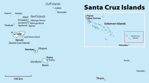
| Outline map of the Santa Cruz Islands | ||
| Waters | Pacific Ocean | |
| Archipelago | Santa Cruz Islands | |
| Geographical location | 11 ° 36 '39 " S , 169 ° 51' 1" E | |
|
|
||
| length | 876 m | |
| width | 576 m | |
| surface | 37 ha | |
| Highest elevation | Te Maunga 65 m |
|
| Residents | 223 (2009) 603 inhabitants / km² |
|
| main place | Lotoapi (district of Mua) | |
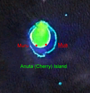
| NASA satellite image Geocover 2000 | ||
Anuta , also Anuda , formerly Cherry Island , is a small island in the southeastern part of the Santa Cruz Islands , which belong to the island state of Solomon Islands . Anuta was discovered for Europe by the British captain Edward Edwards , whom the Admiralty had sent to search for the mutineers of the Bounty . He reached the island with his frigate Pandora on August 12, 1791 , without going ashore, and named it Cherry.
geography
Geographically, Anuta belongs to the Melanesian part of Oceania . The island is about 500 km east-southeast of Nendo , the main island of the Santa Cruz group, in the Temotu province of the Solomon Islands. Anuta is of volcanic origin but is surrounded by a coral reef . At its highest point, it rises approx. 65 m above sea level and has a diameter of only approx. 750 m.
Anuta has two very small side islands : Te Fatu with an area of 0.1 hectare is 665 meters northeast, and the approximately 0.5 hectare Fatu'omanga island about 1.3 kilometers southeast and thus well outside the coral reef surrounding the main island. Both have no significant vegetation.
population
The island is inhabited by about 300 people. Similar to the inhabitants of the relatively close (132 km southwest) Tikopia , these have historically Polynesian roots. They speak a dialect of Polynesian called "Tikopia-Anuta" belonging to the Samoan branch of the Polynesian languages . Anuta is therefore one of the Polynesian exclaves outside the Polynesian triangle .
Originally, the two villages Mua (main town, further east, word meaning "front") and Muri (word meaning "back") were distinguished in the southeast. Today these are combined to form the main town of Lotoapi (also Rotoapi). The second village, Vatiana (Vaisana), is 200 meters west of Rotoapi.
resources
Anuta is not overly fertile. That is why fishing is of great importance for supplying the population with protein. In the past, the inhabitants also used the island of Fatutaka , located around 50 km to the southeast, for agriculture in order to expand their livelihoods. Fatutaka, also of volcanic origin, is the easternmost island of the island state of Solomon Islands.
literature
- Richard Feinberg: The "Anuta Problem": Local Sovereignty and National Integration in the Solomon Islands. In: Man. New Series 21, 3, 1986, ISSN 0025-1496 , pp. 438-452.
- Richard Feinberg: Anuta: Polynesian Lifeways for the Twenty-First Century , Second edition. Waveland Press, Long Grove 2004.
Web links
Individual evidence
- ^ John Dunmore: Who's who in Pacific navigation. University of Hawaii Press, Honolulu HI 1991, ISBN 0-8248-1350-2 , pp. 95-96.
- ↑ Anuta - Settlements
- ^ Raymond Firth: Anuta and Tikopia: symbiotic elements in social organization. In: The Journal of the Polynesian Society , Volume 63 No. 2, 1954, pages 87-132, map on page 90


