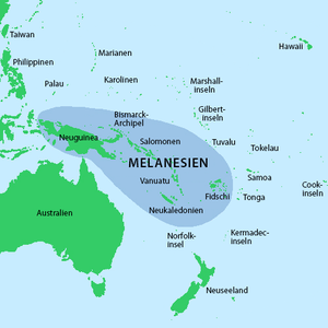
Melanesia
Melanesia (from ancient Greek μέλας melas "black" and νῆσος nēsos "island") is the name given to the Pacific archipelagos that were populated by dark-skinned people who speak neither Polynesian nor Micronesian languages . The islands are northeast of Australia .
geography
The region has an area of 940,000 km² on which about 10 million people live. The region includes the states of Papua New Guinea , Solomon Islands , Fiji and Vanuatu , the Indonesian region of Western New Guinea , the French overseas territory of New Caledonia and the Australian Torres Strait Islands . Ethnic groups that are counted among the Melanesians also live in the surrounding regions.
population
According to the UN, Melanesia had a population of around 10.3 million in 2017. The population growth rate of Melanesia has been among the highest in the world in recent decades and has only started to slow down in recent years. Many residents of the Melanesian Islands are threatened by rising sea levels.
development
| year | population |
|---|---|
| 1950 | 2,165,340 |
| 1960 | 2,663,684 |
| 1970 | 3,399,118 |
| 1980 | 4,431,111 |
| 1990 | 5,669,948 |
| 2000 | 7,193,988 |
| 2010 | 8,983,311 |
| 2017 | 10,320,506 |
Source: UN
See also
Web links
Individual evidence
- ↑ World Population Prospects - Population Division - United Nations. Retrieved July 2, 2018 .

