Santa Cruz Islands
| Santa Cruz Islands | ||
|---|---|---|
| Waters | South pacific | |
| Geographical location | 10 ° 50 ′ S , 166 ° 30 ′ E | |
|
|
||
| Number of islands | about 40 | |
| Main island | Nendo | |
| Total land area | 813 km² | |
| Residents | 11,000 | |
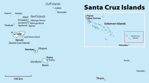
The Santa Cruz Islands are an archipelago that belongs to the Temotu province of the island state of the Solomon Islands . They are located in the western Pacific Ocean , belong to Melanesia and are about 400 km southeast of the main group of the Solomon Islands . In fact, geographically they form more of a unit with the island state of Vanuatu in the south . The Santa Cruz Islands are relatively young in terms of geological history; they were formed less than five million years ago when two continental plates collided under the ocean floor.
The archipelago has an area of around 815 km² and covers
- Duff Islands , 14 km²
- Reef Islands , 29 km²
history
The islands were discovered for the European world in 1595 by the Spaniard Alvaro de Mendaña de Neyra . The French circumnavigator Jean-François de La Pérouse capsized his ship Astrolabe in 1788 off the island of Vanikoro , one of the Santa Cruz islands. In 1828 Jules Dumont d'Urville found parts of the wreckage of La Pérouse's ship off the island. As part of the fighting for the Solomon Islands during the Pacific War in World War II , the Battle of the Santa Cruz Islands took place northwest of the archipelago on October 26, 1942 .

