Makira
| Makira | |
|---|---|
|
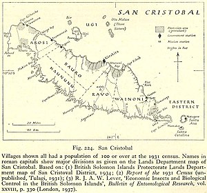
Map of the island, with districts: Arosi, Haununu, Bauro, Ravo, Wainoni, Eastern |
|
| Waters | Pacific Ocean |
| Archipelago | Solomon Islands |
| Geographical location | 10 ° 27 ' S , 161 ° 53' E |
| length | 135 km |
| width | 40 km |
| surface | 3 190 km² |
| Highest elevation | 1250 m |
| Residents | 33,529 (2009) 11 inhabitants / km² |
| main place | Kirakira |
| Topographic map | |
Makira (also San Cristóbal ) is with an area of 3190 km 2 the largest island in the province of Makira and Ulawa in the Solomon Islands . Owaraha (formerly Santa Ana ) and Owariki (formerly Santa Catalina ), the neighboring islands to the southeast, also belong to the province .
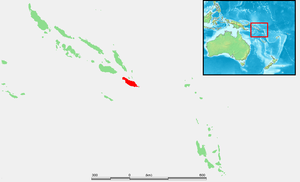
Makira is located 64 km southeast of Guadalcanal . It is also south of Malaita . The capital is Kirakira , located on the north coast of the island . The mountains of the rocky island rise up to 1250 meters in their middle. Only a few tourists visit it. Most of the population is made up of Melanesians . There are several coconut plantations and trading posts on the island.
The first known sighting of Makira by Europeans took place in June 1568 by the Spanish expedition of Alvaro de Mendaña de Neyra . This discovery came during a local sea voyage made by Alférez Hernando Enriquez with the Brigantine Santiago under his command from Guadalcanal, with Hernán Gallego as the pilot. They mapped the island as San Cristóbal .
Web links
Remarks
- ^ San Cristóbal , in: Encyclopædia Britannica online.
- ^ Andrew Sharp: The discovery of the Pacific Islands , Oxford, 1960, pp. 46 f .; Donald D. Brand: The Pacific Basin: A History of its Geographical Explorations , The American Geographical Society, New York, 1967, p. 133.


