Owaraha
| Owaraha | ||
|---|---|---|
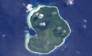
| NASA satellite image of Owa Raha | ||
| Waters | Pacific Ocean | |
| Archipelago | Solomon Islands | |
| Geographical location | 10 ° 49 ′ 54 ″ S , 162 ° 28 ′ 1 ″ E | |
|
|
||
| length | 5.6 km | |
| width | 4.5 km | |
| surface | 15.7 km² | |
| Highest elevation | Faraina 143 m |
|
| Residents | 1547 (23 November 2009) 99 inhabitants / km² |
|
| main place | Ghupuna | |
| Santa Ana as part of the Eastern District of Makira, with the village of Natagere on the east coast | ||
Owaraha , also Owa Raha (formerly Santa Ana ) is an island of the island state of the Solomon Islands in the Pacific .
geography
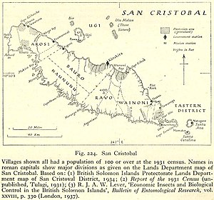
Owaraha belongs to the province of Makira and Ulawa . It is an upscale atoll , approximately 5.6 km long and up to 4.5 km wide. The island is separated from Makira (formerly known as San Cristóbal ) by an approximately 7.5 km wide arm of the Pacific. 2.8 km south of Owaraha is the smaller island of Owariki (Santa Catalina). In between lies the Paraghawa Strait . Of the four villages on the island, Ghupuna on the west and Nafinotoga on the south-east coast are the largest, followed by Nataghera (Natagera) on the east coast. The fourth, Taguruaera, is in the interior of the island on the road between the first two villages mentioned.
The highest point on Owaraha is the Faraina at 143 m above sea level. The island has two brackish water lakes: Wairafa in the north with dimensions of 1,600 × 700 m and Waipiapia in the south with 400 × 300 m.
history
Owaraha was found in two caves at Rate and Feru as early as 1280 BC. Settled. 1568 saw the Spanish navigator Alvaro de Mendaña de Neyra , that of Peru from the terra australis should find the island for the European world.
population
The residents of Owaraha speak the Owa language ( ISO 639-3 : stn ), which is also spoken in Owariki and in the eastern part of Makira, for example in Star Harbor . This is sometimes referred to as a kahua .
In 1932 the Austrian ethnologist and photographer Hugo Bernatzik visited the island. During his stay, Bernatzik documented and photographed the daily life of the residents. He was convinced that the culture he was documenting was doomed to collapse with the western world. In 1936 his book Owa Raha was published.
tourism
There is a dirt runway for airplanes in the south of Owaraha . The IATA airport code is NNB and the ICAO code is AGGT. The "port" for motorized canoes from the capital of the neighboring island of Makira, Kirakira , is Mary Bay, which can be reached after a crossing of up to 4 hours.
In Wataghera there are two ancestral houses in which the remains of the dead have been kept for about 500 years. Photography is usually not allowed there, women are not allowed to enter the houses.
Souvenirs from the island are wooden bowls that are modeled in the shape of sharks.
literature
- Hugo Bernatzik: Owa Raha , Gutenberg Book Guild , Vienna / Zurich / Prague 1936
- Doris Byer: The Big Island: South Pacific Life Stories. Autobiographical reports from the south-eastern Solomon Islands archipelago since 1914 , Böhlau, Vienna / Cologne / Weimar 1996. ISBN 3-205-98441-2 .
Web links
- Solomonislands.com ( Memento of January 17, 2010 in the Internet Archive ): Santa Ana (Engl.)


