
Start-and runway

The runway (SLB) or slope is the - often fortified - surface of an airfield or aircraft carrier , on the one hand launching aircraft speed and up to the take-off and lift off, on the other hand landing touchdown and slow down or roll out aircraft. A longer runway length is required for the acceleration distance than for the landing distance. Most runways are used for both take-offs and landings; in rare cases, factors such as an obstacle situation or special taxiing logistics may require exclusive use for take-offs or landings. This is e.g. B. the case at Frankfurt am Main airport .
For this reason, only the term runway (abbreviated as RWY) exists in English . In the German terminology is synonymously for runway and runway or short track used. In Switzerland, Austria and in German-speaking aeronautical radio , the term runway is used exclusively .
For safety reasons, a runway is only used by one aircraft at any given time, especially when it is used as a runway and a landing strip. Exceptions are the aircraft tow or the joint take-off during formation flight . However, the take-offs and landings sometimes take place in very rapid succession; Especially at airports with high occupancy, it can often be observed that an aircraft takes off at the end of the runway, while another aircraft is about to land on the other side. Because every aircraft creates a wake vortex behind it, a certain distance is maintained between aircraft taking off and landing.
These railways are part of the airport infrastructure .
Structural execution
Surface / substructure


Depending on the load to which a runway is exposed during operation, different construction principles can be considered. While light aircraft can take off and land on simple, short-cut grass strips, most heavy commercial aircraft cannot do so because their landing gear would deform the ground too much. Most commercial airports therefore have at least one paved runway. The thickness of the covering ranges from 25 cm to 130 cm for heavily used railways such as the new south runway at Berlin Brandenburg Airport . Either asphalt or concrete is used as the surface . Due to its longer service life of up to 40 years, concrete is mainly used at large airports, while the cheaper asphalt with a service life of 15 to 20 years is used at smaller airports. The surfaces must have good friction behavior in all expected weather conditions and be free of irregularities in order to ensure the best possible flight movements. In the case of concrete runways, the floor is often grooved in the transverse direction so that the water can drain off and there is no aquaplaning .
Unpaved slopes are made up of sod, gravel, dry soil or sand. There are also slopes on suitable dry salt lakes, such as at Edwards Air Force Base . They, too, are built as level as possible and mowed briefly when there is grass to ensure that the aircraft can roll freely. They can be unusable after heavy rainfall. To prevent this, the soil can either be drained before the construction of the airfield or reinforced with inlaid mesh material (for example at the Speck-Fehraltorf airfield in Switzerland).
The carrying capacity of runways can be classified using the Pavement Classification Number .
Landing areas for seaplanes are also sometimes referred to as runways.
length and width


The length and width of the runway depends on the "control aircraft". This is the aircraft that is most frequently operated on the relevant runway. If necessary, a special permit will be issued for larger aircraft. The use of large aircraft on intercontinental routes can lead to a very high maximum take-off weight, which in turn can require a runway length of 3000 to 4000 meters. If the required length is not given, this leads to limitations of the aircraft with regard to their weight and consequently their range . Location-related factors also have an impact on the minimum length of the slopes. Reduced engine performance and impaired lift are caused by:
- high temperatures at the location (warm air expands and is therefore thinner than cold). Therefore, the lanes must be lengthened as a percentage depending on the airport reference temperature. This corresponds to the average daily maximum temperature of the hottest month of the year.
- the high altitude of an airfield above the sea, resulting in lower air pressure .
The width of the runways is also influenced by the technical data of the aircraft. For most common, large types of aircraft, the standard width of many runways of 45 meters is sufficient. A wide- bodied aircraft like the A380 requires a runway width of 60 meters. However, the A380 Airport Compatibility Group (AACG) issued a special permit for 45-meter-wide runways for certain airports.
At the military airfields, the runways are also built according to the types of aircraft they are to be used by. Many jet aircraft require a runway length of around 2.5 kilometers, while numerous (especially smaller) propeller planes manage with very short distances.
For some ultralight aircraft , a take-off or landing distance of well under 100 meters is sufficient. Microlight airfields typically have grass runways around 250 meters in length.
According to ICAO Annex 14, the webs are divided into four length and six width categories which are expressed by a two-digit code:
| 1 position | 2nd position | ||
|---|---|---|---|
| Code number | Reference runway length 1 | Code letter | Wingspan |
| 1 | less than 800 m | A. | less than 15 m |
| 2 | 800 to less than 1200 m | B. | 15 to under 24 m |
| 3 | 1200 to under 1800 m | C. | 24 to less than 36 m |
| 4th | 1800 m and more | D. | 36 to less than 52 m |
| E. | 52 to under 65 m | ||
| F. | 65 to less than 80 m | ||
- 1In Spain the first position is defined differently: Airport length classes Spain
- A minimum width is also required for classification, otherwise this run will not be approved for new systems.
The world's longest civil aviation runway is 5500 meters (14/32) long at Qamdo-Bamda Airport (ICAO code: ZUBD) and is located in the Tibet Autonomous Region (PR China) at an altitude of 4,334 meters above sea level. The longest runways of all can be found at military test sites on dry salt lakes such as Groom Lake and Edwards Air Force Base with lengths of up to 11.92 kilometers. Yap Airport ( Micronesia ) has the shortest runway at an international airport for aircraft with jet engines, at 1,469 meters. The Brazilian airport of Rio de Janeiro-Santos Dumont , which is also used by jet aircraft, has a runway length of just 1323 meters. Immediately around the runway, the safety strip is legally defined. Depending on the size of the runway and its use ( instrument flight (IFR) / visual flight (VFR)), this has a width of 30 meters (VFR) to the right and left of the runway up to 150 meters (IFR, code number 3 and 4) each Side and must be leveled and free of obstacles. For air traffic control reasons, only the glide path transmission mast and the monitor mast may be obstacles within the strip . The strip starts at 30 (VFR) to 60 meters (IFR) in front of the track and ends at 30 or 60 meters after the end of the track. The RESA (runway end safety area) is located in front of and behind the strip. The RESA has a length of min. 30 (VFR) up to 90 meters (IFR, recommended by ICAO 240 meters for IFR). The width is that of the strip, but at least twice the width of the web.
The point on the track at which a landing aircraft must touch down at the earliest is called a landing threshold (English: Threshold ), respectively. The marking on this threshold looks like a zebra crossing . A distinction must be made between this and the real touchdown point , which can be more or less far behind the threshold depending on the length of the runway, aircraft and wind conditions.
At the end of the lane, depending on the obstacle situation, a clearway can be set up. With the existing take-off run distance TORA (take off run available), the length of these results in the TODA (take off distance available). A stopway could also be set up under certain circumstances . This stopway is added to the existing TORA and results in the maximum ASDA (accelerate stop distance available).
Alignment
While in the early days of aviation the airfields in Germany were mostly round and thus usable in every direction, today the runways are built in such a way that their direction is adapted to the local wind conditions. Airplanes always take off and land against the wind in order to generate maximum lift and to shorten the take-off and landing distance. For this reason, the main runway is ideally built according to the main wind direction . Slight deviations from this may be necessary due to geographical conditions and approach procedures . The location of other runways should be chosen so that the airport's usability factor is at least 95%. If cross winds are often so strong at a location that the main runway cannot be operated permanently, there should be a cross wind runway in a crossed orientation. The smaller the aircraft that is to use the train, the lower the permissible cross wind component. To plan the runway alignments, observations of the wind distribution should be made several times a day over a period of at least five years in order to ensure the highest possible usability of the runways.
A particularly difficult situation arises when wind shear situations ( English : wind hear ) prevail on the runway. Wind shear are updrafts and downdrafts that are diverted through the ground and appear as strong gusts. In the weather radar, bad weather areas can be recognized and avoided far in advance, but wind shear is not displayed.
However, there is now a so-called windshear warning system , which not only detects a windshear when it is currently occurring (caused by more than 15 kts vertical or 500 fpm horizontal deviation (def.)), But also a so-called "Predictive Windshear System", which also detects large updraft and downdraft fields in front of the aircraft. If the risk becomes too great, you have to land at another airport.
Configurations
Meteorological and geographic factors at airfields require different configurations of the runways. Possible configurations are the one-way, parallel, cross and V-track systems and combinations thereof. The capacity , as the maximum possible number of flight movements , is largely, but not exclusively, determined by the runway system. Other capacity-limiting influencing factors are wind and visibility conditions, delays in the event of high traffic volumes, staggering, existing navigation aids, aircraft mix, approach and departure procedures as well as the capacity of the aprons and taxiways . The capacity thus determined does not represent an absolute value, but a simulated approximate value.
The simplest variant is the one-way system, in which there is only one runway in the main wind direction. It becomes v. a. Used by smaller airfields that have no unfavorable cross winds. With this system, 180,000 to 230,000 flight movements can be carried out annually, depending on the ground engineering facilities.
In a parallel track system, there are two or more tracks in a parallel arrangement. As with the one-way system, this assumes that there are hardly any strong headwinds at the location that would restrict operation. The distance and the offset of the tracks from each other are decisive for how many movements the capacity increases. This distance, which determines the operating mode, is measured using the distance between the track center lines. There is a distinction between close, wide and medium path distances (“close”, “far”, “intermediate”). A distance of over 1035 meters means that the tracks can be operated independently of one another under any conditions (exception: threshold offset of the two tracks). This leads to a doubled capacity of a maximum of 120 movements per hour or 310,000 to 380,000 flight movements per year. Independent operation of both lifts is not possible if the distance is less than 1035 meters. Depending on the distance, different dependencies arise, which can reduce the capacity of the rail system to the maximum capacity of a one-way operation.
The cross track system consists of two tracks with different orientations that cross at one point. The different alignment of the tracks is caused by winds from different directions. If there were only tracks in one direction at such locations, this would lead to a capacity restriction in strong crosswinds. The different orientation of the tracks ensures that a track always corresponds to the wind conditions. At low wind strengths, both lifts can even be operated. In addition to the operating direction, the capacity of the cross lane system is heavily dependent on the position of the intersection of both lanes. The closer the distance of the intersection from the ends of the tracks, the higher the capacity of the system.
The configuration of the V-track system is similar to the cross-track system, but the two tracks of different geographical directions do not intersect. The runway with the predominant operating direction is also referred to as the main runway, and the other as the cross wind runway. In strong winds, the capacity is limited, as in this case only one lift can be operated. In contrast, both lanes can be used simultaneously in light winds. A higher capacity is achieved when the movements take place away from the V. In this case, up to 100 flight movements per hour can take place.
One future concept is the circular “Endless Runway”, which is intended to significantly reduce land consumption , noise pollution and the costs of future runways.
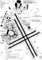
- Exemplary arrangements

Triple Intersection of Lanes ( Ronald Reagan Washington Airport , USA)
Quadruple intersection of lanes ( San Francisco International Airport , USA)

Six-way intersection of lanes ( Boston Airport , USA)


Tilt
The runway in Europe is only allowed to have a slight angle of inclination of a few degrees because it would make it more difficult to take off uphill and landing on an inclined runway is considerably more difficult. For every 1% longitudinal inclination of the runway, there must be an extension of 10% of the reference runway length, as a difference in height within the runway results in a lower acceleration of the aircraft.
Maximum pitch:
- 2% for code numbers 1 and 2
- 1% for code numbers 3 and 4
Exceptions: The Courchevel Alpine Airfield has a slope of 18.5% or approx. 11 °. With such Altiports , landing in one direction and taking off in the opposite direction is often only possible due to the steep incline or other geographical features.
Special case aircraft carrier
On large aircraft carriers with an angled flight deck, there are two separate runways. While you can only take off beyond the bow, the longer runway, which is angled a few degrees from the longitudinal axis, can be used for take-offs and landings. Smaller carriers with a straight flight deck and a combined runway use a “ ski jump ” at the end of the runway , which catapults the aircraft into the air.
Safety devices
In order to prevent landing aircraft from being shot out over the runway, so-called EMAS ( Engineered Materials Arrestor System ) can be installed at the ends of the paved surface of runways bordering built-up areas or crossing roads . These are made of porous material and allow the aircraft to sink in when rolling over and thus slow it down.
Runway identification


The runways are identified by their runway designator , which is based on the degrees on the compass rose . The number of degrees is divided by ten and rounded commercially. For example, if a track runs in an east-west direction (90 or 270 degrees), it will be marked 09/27. The smaller number always comes first, regardless of the direction in which the railway is operating. A straight path marked 04 in one direction will lead the marking 22 in the opposite direction . The direction of the tracks differs by 180 degrees, so the marking by 18. Each of these two numbers is painted as a large white number on the respective threshold (start of the landing route LDA) of the track, so that the pilots can already see them from the air Distance can be detected.
Since the most important reference for course information in aviation is traditionally the magnetic compass , the runway markings are also based on the magnetic north direction. A runway z. B. with the marking 36 (for 360 ° or north) does not necessarily point to the geographic north pole , but only in the north direction of the earth's magnetic field measured there . The deviation between geographic and magnetic north is only small in Germany (up to 4 ° in 2018), but can be considerably higher elsewhere; so it lies z. B. in the Brazilian Recife at 22 ° West and in Thule (Greenland) currently (2016) even at 47 ° West.
Since the earth's magnetic field changes continuously, the identifiers of existing orbits can also change. For example, runway 15/33 at Sylt Airport was renamed to 14/32 in June 2006 because the variation had changed so much that the rounded value was only 140/320 degrees instead of 150/330 degrees.
If an airfield has two runways that run parallel and therefore have the same identification numbers, the letter R (from the English right ) is added to the runway on the right and an L (from the English left ) to the left runway . In such a case, the full identification would be, for example, runway 07R and runway 07L . If there is even a third parallel run, the letter C (from the English center ) is used for the middle runway . If there are more than three parallel lanes (for example at Los Angeles International Airport ), the names for two lanes are often rounded off, while the names for the other two lanes are rounded up. The four orbits in compass direction 249 are then designated as 25R, 25L, 24R and 24L, for example.
Only one direction is used in flight operations. This is determined by the tower and is usually based on the current wind direction in order to enable aircraft take-offs and landings against the wind in order to achieve short take-off runs and landing routes. It may well happen that the operating direction is changed during flight operations. Operating direction 18 then becomes 36 , that is, take-offs and landings no longer take place in the south but in the north.
Markings

The runways continue to have white markings that help the pilot to identify the various sections of the runway and their central axis during take-off and especially when landing, in order to maneuver safely in this way. In the picture on the right, the marking applies to a code number 4 lane (lane length greater than 1800 meters).
Lighting

For take-offs and landings in the dark and in fog , some runways have lights that mark the side boundary, the middle, the beginning and the end of the runway and some of the sections.
- All taxiways (taxiways) are lit with green lights (the edges blue), from the taxiway stop to the runway center line green (green-yellow, if CAT-II / III protection zones are affected by the ILS ).
- The runways are lit with white lights at the edges. The centerline marker is also fired white; with CAT II / III, 600 meters of the last 900 meters are coded red and white and the last 300 meters only red. The end is lit red, the landing threshold green, the runway touchdown zone white (only with CAT II / III).
- The taxi stop is fired in red and there may be illuminated information boards (yellow). CAT-II / III stopping points are also lit in red and provided with red signs.
- Intermediate stop positions are lit orange.
- The apron has blue edge lights and headlights.
Approach lights are differentiated for precision approaches and non-precision approaches . Precision approaches require a minimum length of 720 meters. Approach lighting (for ILS category CAT I), for CAT II and CAT III 900 meters.
Runways for non-precision approaches should be equipped with approach lights that are at least 720 meters long. Exceptions are possible up to 420 meters. Under certain physical conditions (slope or similar), a shorter length of the approach lights is also possible, but subject to further conditions, for example in Allendorf / Eder: GPS approach procedure, but only 150 meters approach lights (however, the MDH is increased ).
Optical approach aids can also be installed next to the runway. VASI enables the three-degree descent to the runway to be checked using two or four spotlights arranged one behind the other ("White white: your height !, red white: you're right !, red red: you're dead.") , The Precision -Approach-Path-Indicator-System ( PAPI ) offers a more precise landing aid and consists of four lamps next to each other. Here, too, there is a color code consisting of red (too low) and white (too high); the correct glide path is achieved when the pilot sees two red and two white lights.
business
At larger airports, aircraft are often brought from the runway to the parking position by a follow-me car . In particular, it is common for aircraft that are not processed at a gate or that taxi independently to the General Aviation Terminal (GAT) to be accompanied by a follow-me car to their parking position. At the gates of large airports, instructions are given by ground staff, so-called marshallers .
In appropriate weather conditions, the runway can only be used if it has been cleared of snow and treated with a movement area deicer to thaw or to prevent ice formation .
Airfields with many runways

Dallas / Fort Worth Airport has seven runways. Chicago Airport , with its nine runways, is the airport that currently has the largest number of runways.
The largest airport in the USA, Denver Airport , has six lanes , while the airport with the world's highest passenger numbers, Atlanta Airport , has "only" five lanes. The largest Dutch airport, Amsterdam , also has six lanes. The Paris-Charles de Gaulle airport , the Frankfurt airport and the largest Japanese airport, Tokyo International Airport , have four lanes, while the largest Belgian airport, Brussels Airport , has three tracks. The London Heathrow Airport (the largest international passenger traffic in Europe, the third largest overall passenger traffic worldwide), however, has only two lanes. The airports Toronto-Pearson , George Bush Intercontinental Airport near Houston in the US state of Texas and the airport Logan International Airport from Boston all have five runways. The airport Detroit Metropolitan Airport has six runways.
The new Istanbul Airport, which opened in October 2018, is to become the “largest airport in the world” in its final expansion with six runways (and 150 million passengers annually) on an area of around 9,000 hectares . Dubai is also building the “largest airport in the world”, Al Maktoum International Airport . In addition to the existing Dubai International Airport, it will have five parallel runways and a capacity of 160 million passengers. This is to the airport Beijing Daxing , which is scheduled for 2020, will be surpassed with eight planned runways.
Runways of the German airfields
In an international comparison, Germany's airfields have a relatively small number of runways. The list of international commercial airports according to the guidelines of the BMVI includes 16 airports. Among them, only Frankfurt am Main Airport has four runways. Hanover and Cologne / Bonn airports are currently equipped with a maximum of three runways . Six of them have two slopes: Berlin-Tegel , Bremen , Düsseldorf , Hamburg , Leipzig / Halle and Munich . The remaining seven airports only have one runway.
- The new Berlin Brandenburg Airport (BER) will have two parallel runways: the former southern runway at Berlin-Schönefeld Airport , which will be extended to 3600 meters as part of the new construction, and a new runway 4000 meters long and 60 meters wide .
- Nuremberg Airport : Most of the renovation work on the 2,700-meter-long runway was completed in summer 2010. The piste, which is more than 50 years old at the core, is to be gradually renewed and equipped with modern technology in several construction phases.
See also
- List of the largest commercial airports
- List of commercial airports in Germany
- Instrument Landing System (ILS)
- Motorway makeshift airfield
- Take-off and landing site
- List of the longest runways
- Crossings of railway lines with runways
- Gibraltar Airport ; here the street crosses the runway
Web links
Individual evidence
- ↑ AIP GEN 3.4, online at Eurocontrol (PDF)
- ↑ High performance around the clock. In: wirtgen-group.com. Wirtgen Group, accessed on March 2, 2014 .
- ^ A. Wells, B. Young: Airport Planning & Management . 5th edition. New York 2004, p. 102 .
- ↑ Airfield data for Welzow Sedlitzer See airfield ( Memento from February 20, 2009 in the Internet Archive )
- ↑ U. Häp: Evaluation procedure for planning variants of runways for an airfield expansion . (= Series of publications by the Institute for Transport and Spatial Planning, University of the Federal Armed Forces, Munich. Issue 51). Neubiberg 2007, DNB 985218754 , p. 51 f.
- ^ A. Wells, B. Young: Airport Planning & Management . 5th edition. New York 2004, p. 105 .
- ↑ ICAO Doc 9157: Aerodrome Design Manual. (PDF) Part 1 - Runways. In: bazl.admin.ch. International Civil Aviation Organization , March 1, 2011, p. 11 , accessed on November 11, 2016 .
- ^ H. Mensen: Planning of the installation and operation of airfields . Berlin 2007, p. 324 .
- ↑ U. Häp: Evaluation procedure for planning variants of runways for an airfield expansion . Neubiberg 2007, p. 53 f.
- ^ H. Mensen: Planning of the installation and operation of airfields . Berlin 2007, p. 325 ff .
- ^ Project "Endless Runway": Researchers plan a circular airport. At: n-tv , March 29, 2017.
- ↑ NOAA calculation page for the variation
- ↑ U. Häp: Evaluation procedure for planning variants of runways for an airfield expansion . Neubiberg 2007, p. 50 f.