
Motorway makeshift airfield


An emergency landing site is a stretch of road that can be converted into a simple airfield or a runway in a relatively short time . If the road is a motorway, it is also referred to as a temporary motorway airport . In principle, however, all possible roads are suitable for this, if only a sufficiently large flat and paved area is available. It is primarily used for the take-off and landing of military aircraft, especially combat aircraft . In areas where otherwise there are no four-lane or multi-lane roads, a short section of an otherwise two-lane road has been extended to many times the normal width of the lane.
In the Federal Republic of Germany the official name is Notlandeplatz (NLP). In the German Democratic Republic , the term Autobahn section (ABA) was used. In Switzerland it was called the Autobahn emergency landing runway .
Germany
Characteristics
A makeshift motorway airport is around three kilometers long on average and characterized by a straight, level roadway without overpasses . The central reservation is usually concreted or asphalted and the central barrier is easy to dismantle. This means that the full width of the motorway is available as a runway .
In this area, high-voltage lines also cross under the motorway as underground cables or are routed in a wide area around the motorway landing area. The overhead line masts are often designed in a noticeably low construction and marked as obstacles to air traffic with a red and white paint.
At the ends of an emergency landing site there is a larger paved area, which is often trapezoidal and used as a parking lot . Airplanes can be parked on this. The landing sites have a junction with another major road on at least one side so that traffic can flow away and supplies can be brought in.
During the Cold War , such a makeshift airfield would have been ready for use within a few hours in the event of a crisis, since everything was prepared and only had to be set up. A mobile tower , mobile radar , etc. were kept nearby. A level area with access was prepared for the tower, radar and other necessary equipment (mostly halfway along the runway) .
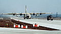
The makeshift autobahn airfield on the A 29 at the Ahlhorn junction , for example, was put into operation for 48 hours in 1984 as part of the NATO exercise Highway 84 , during which time machines of the Transall , F4-Phantom , Tornado and Thunderbolt types started and landed there II .

Guardrails set in ground sockets and a central strip concreted throughout

Parking lot as a parking area for aircraft

MAN 630 as a mobile control tower

Hercules C-130 lands near Ahlhorn
Hercules transporter behind Follow Me vehicle

Thunderbolt II before launch


history

The first highway runways appeared in the late years of World War II when many regular airfields and airports were destroyed by bombers . During the Cold War, makeshift motorway airfields in the Federal Republic of Germany and the GDR were maintained, made available or new ones set up. The Swiss Army also used such sections of the motorway. Sometimes the originally civil motorway plans were changed in order to be able to set up a makeshift airfield. Since the end of the Cold War, most of the landing sites have not been maintained and are gradually disappearing.
The Ramstein Air Base emerged from a motorway landing pad of the German Air Force, which was set up on the Reichsautobahn Kaiserslautern – Saarbrücken in the local area of Ramstein. This was conquered by the advancing American armed forces towards the end of the Second World War and over the years it was developed into the most important European base for the air transport of the US armed forces. Today the motorway from Kaiserslautern to Saarbrücken runs between the junction Kaiserslautern-Einsiedlerhof and the Landstuhl junction in a generous southern arc around the air base. Large parts of the old Reichsautobahn route are still preserved and are used as access to the air base; the course of the old route can be seen very well in aerial photographs.
For example, in the last years of the war , the B&V aircraft yard in Wenzendorf used the adjacent Reichsstraße 3 (now the B 3) as a runway and the forest next to it to camouflage their hunting protection .
Makeshift autobahn landing sites

| |||||||||||||
Overview map of federal motorways in Germany with temporary landing areas dismantled |

- A 1 between Ladbergen and Lengerich (length: 2100 m) 52 ° 10 ′ N , 7 ° 46 ′ E (dismantled in October 2006)
- A 1 between Vechta and Lohne-Dinklage (length: 3000 m) 52 ° 43 ′ N , 8 ° 10 ′ E (dismantled)
- A 1 between Lohne-Dinklage and Holdorf 52 ° 38 ′ N , 8 ° 8 ′ E (dismantled)
- A 1 between Greven and Münster Nord (length: 2100 m) 52 ° 4 ′ N , 7 ° 37 ′ E (dismantled)
- A 1 between Delmenhorst-Süd and Wildeshausen-Nord 52 ° 57 ′ N , 8 ° 33 ′ E (dismantled)
- A 1 between Sittensen and Heidenau 53 ° 19 ′ N , 9 ° 35 ′ E (dismantled)
- A 4 between Ottendorf-Okrilla and Pulsnitz 51 ° 10 ′ N , 13 ° 53 ′ E (dismantled after 1990)
- A 6 between Kirchardt and Sinsheim-Steinsfurt (west of Heilbronn) 49 ° 13 ′ N , 8 ° 58 ′ E (dismantled in 2011 as part of the six-lane expansion)
- A 6 between Kirchberg and Crailsheim (length: 2400 m) 49 ° 11 ′ N , 9 ° 59 ′ E
- A 7 between Tarp and Schleswig / Schuby (length: 2400 m) 54 ° 37 ′ N , 9 ° 26 ′ E (dismantled)
- A 7 between Schleswig / Jagel and Owschlag (length: 2000 m) 54 ° 26 ′ N , 9 ° 36 ′ E
- A 9 between Dessau-Süd and Zörbig (length: 5000 m) 51 ° 41 ′ N , 12 ° 12 ′ E (attached concrete guardrails; used as a racing track in the 1950s)
- A 10 between Dreieck Havelland and Falkensee 52 ° 41 ′ N , 13 ° 0 ′ E
- A 12 between Storkow and Friedersdorf 52 ° 19 ′ N , 13 ° 51 ′ E
- A 13 between Ruhland and Ortrand 51 ° 26 ′ N , 13 ° 49 ′ E (dismantled between 2000 and 2005)
- A 14 between Döbeln-Nord and Leisnig near Strocken 51 ° 12 ′ N , 13 ° 0 ′ E (dismantled)
- A 15 between Forst and Bademeusel (length: 2300 m) 51 ° 41 ′ N , 14 ° 41 ′ E
- A 19 between Kessin and Kavelstorf (length: 3200 m) 54 ° 2 ′ N , 12 ° 12 ′ E (2001 partially overbuilt by the Rostock cross)
- A 24 between Neuruppin and Herzsprung (length: 3000 m) (dismantled in 2009) 53 ° 0 ′ N , 12 ° 36 ′ E
- A 27 between Nordholz and Neuenwalde (length: 2500 m) 53 ° 43 ′ N , 8 ° 40 ′ E
- A 27 between Uthlede and Hagen 53 ° 21 ′ N , 8 ° 36 ′ E (dismantled in 2005)
- A 29 between Großenkneten and Ahlhorn (length: 2600 m) 52 ° 55 ′ N , 8 ° 10 ′ E (dismantled in October / November 2006)
- A 43 between Nottuln and Dülmen Nord (length: 2500 m) (dismantled) 51 ° 53 ′ N , 7 ° 20 ′ E
- A 44 between Büren and Geseke (length: 3200 m) 51 ° 36 ′ N , 8 ° 33 ′ E
- A 57 between the Alps and Sonsbeck (length: 3500 m) 51 ° 35 ′ N , 6 ° 26 ′ E (dismantled in 2018)
- A 61 between Meckenheim and Bad Neuenahr-Ahrweiler (length: 1900 m) 50 ° 35 ′ N , 7 ° 3 ′ E (was intended for the government bunker)
- A 61 between Bad Kreuznach and Gau-Bickelheim is currently being dismantled (as of June 2012) and has so far been used by the US troops stationed in Bad Kreuznach for rapid relocation to the war zone (length: 1800 m) 49 ° 53 ′ N , 7 ° 57 ′ O
- A 81 between Osterburken and Möckmühl (meanwhile toll bridges on both lanes, north of Heilbronn, length: 3000 m) 49 ° 22 ′ N , 9 ° 26 ′ E
- A 81 between Oberndorf and Rottweil (length: 3000 m) 48 ° 15 ′ N , 8 ° 39 ′ E (attached concrete guardrails)
Austria
In Austria, landings with fighter planes and fixed-wing aircraft on motorways and expressways in the inner-alpine area were last practiced at the end of 1986. Numerous landing sites, which are easily recognizable in the alpine terrain by the unusually straight lines, have now been built over. In the avalanche winter of 1999, the helicopters that evacuated those trapped from Galtür landed on a section of the motorway near Imst, which was intended as a makeshift airfield. A makeshift airfield in Austria for the purpose of military aviation is located next to the military airfield in the Styrian Zeltweg (LOXZ) on the Murtal expressway (S36) between Spielberg and Zeltweg. The temporary runway there begins at StrKM 33,500 in the direction of Vienna and ends at StrKM 36,750. In addition, the Zeltweg / S36 replacement runway has a direct taxiway connection to the hangar building at the military airfield.
Switzerland
For the situation in Switzerland see :
Poland
East of Szczecin, there is the DOL Kliniska at 53 ° 26 ' N , 14 ° 48' O .
Estonia
A makeshift airfield is located on the Jägala-Käravete road (Tugimaantee 13) right next to the (currently unused) Jägala barracks ( 59 ° 24 ′ N , 25 ° 17 ′ E ). American A-10 Thunderbolt IIs rehearsed the landing there in the summer of 2016.
Czech Republic
Měřín Highway Strip : On the D1 motorway (Praha - Brno) between kilometers 137 and 139, at the level of the town of Stránecká Zhoř , there is an intact makeshift airfield of 2500 m length (11/29) between the civilian parking areas (rest area, fast-food restaurant) . The underpass a subordinated road under the highway / runway measures perpendicular width 49 m (instead of the usual here RQ27 ) ( 49 ° 23 ' N , 15 ° 56' O ). At kilometer 139 on the north side (towards Prague) there is a 160 m × 30 m unused parking space. Instead of central guardrails, steel cables are tensioned.
North of Vyškov ( 49 ° 18 ' N , 17 ° 2' O ) is an approximately three-kilometer long runway in addition to the E 462 with wide entrances and ground marks. About 500 meters west of the R 46 expressway, there are decommissioned fighter jets in the Muzeum letecké a vojenské techniky (Museum of Aviation and Military Technology ).
Bulgaria
Road No. 13 between Borovan and Bjala Slatina has been widened from two to five lanes. At the end of the 2-kilometer runway there are around ten splitter boxes for fighter planes. The facility has been unused and heavily overgrown for many years.
Sweden
There are also several road sections in Sweden that can serve as makeshift airfields across the country. During the Cold War era, this was intended as a security measure so that the Swedish Air Force could evade if the main airfields are attacked.
literature
Peter Steinmüller: Die Straße der Piloten , in: VDI nachrichten 29/30 2018, p. 26 f, (here :)
Web links
- Military Airfield Directory
- Autobahn airfields (NLP-Str) at geschichtsspuren.de (formerly lostplaces.de)
- Vehicles makeshift airfield
- Videos of highway landings, among others during the NATO exercise Highway 84
- Entry for Autobahn emergency landing site IV / 1 on the A 61 (makeshift airfield at Meckenheimer Kreuz) in the database " KuLaDig " of the Rhineland Regional Association
Individual evidence
- ^ "Highway 84": The NATO maneuver on the highway. ndr.de, accessed on April 25, 2018 .
- ↑ A-10 Warthogs Land on a Highway in Estonia (low passes, go-around). Retrieved August 12, 2018 .
- ^ Měřín Highway Strip at Military Airfield Directory - Cold War airfields; Retrieved January 19, 2014