Courchevel airfield
| Courchevel Altiport de Courchevel Airport |
|
|---|---|

|
|
| Characteristics | |
| ICAO code | LFLJ |
| IATA code | CVF |
| Coordinates | |
| Height above MSL | 2007 m (6585 ft ) |
| Transport links | |
| Distance from the city center | 2 km south of Courchevel |
| Start-and runway | |
| 04/22 | 537 m × 40 m asphalt |
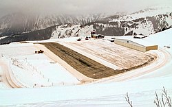
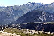
The Airfield Courchevel is a French airfield in the middle of the ski resort Courchevel at an altitude of 2007 m (6600 ft). It is called the Altiport .
The runway is only 537 m long and has a gradient of up to 18.66%. It is therefore not possible for pilots to take off . The Altiport is considered to be one of the most dangerous airfields in the world.
A separate qualification installation is required for the approach , i. H. Approach permission for Altiports, or a six month permission for this airport required.
In the past, the airfield was also served by scheduled flights, most recently with Dash-7 turboprop aircraft from the Tyrolean Airways line . Today the Altiport is used by helicopters and sport aircraft. As a supporting program for the annual Ski Jumping Summer Grand Prix in Courchevel, aerobatic teams use the Altiport as a base.
Web links
Individual evidence
- ↑ Most Extreme Airports ; Channel 5 (France); October 14, 2010
- ↑ World's Most Dangerous Airports: Courchevel Airport at: jaunted.com.
