
Makira and Ulawa
| Makira and Ulawa | |
|---|---|

|
|
| geography | |
| Country: | Solomon Islands |
| Waters: | Pacific Ocean |
| Islands: | Makira , Ulawa , Owaraha , Owariki , Uki Ni Masi , Olu Malau Islands and numerous small. Islands |
| Geographical location: | 10 ° 26 ′ S , 161 ° 52 ′ E |
| Basic data | |
| Surface: | 3188 km² |
| Residents: | 40,420 |
| Population density: | 13 inhabitants / km² |
| Capital: | Kirakira |
| Situation map | |
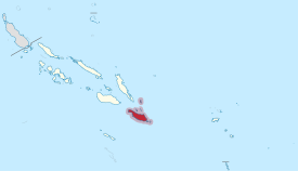 .svg) |
|
The province of Makira and Ulawa officially Makira Ulawa Province, located in the south of the Pacific island state of Solomon Islands . It borders in the north-west on the province of Guadalcanal , in which the Solomonic capital Honiara is located, in the north-east on the province of Malaita and in the south-west on the province of Rennell and Bellona .
The provincial capital Kirakira is located on the northeast coast of Makira (formerly: San Cristobal), the largest island of Makira and Ulawa with 3,090 km² . The much smaller island of Ulawa (63 km²) is about 70 km to the northeast. The province also includes numerous smaller islands, including Owaraha , Owariki , Uki Ni Masi and the Olu Malau Islands .
The area of all the islands of Makira and Ulawa is 3,188 km². After the census of 2009 40.420 people lived in the province, the majority of the island Makira.
See also
Individual evidence
Central | Choiseul | Guadalcanal | Isabel | Makira and Ulawa | Malaita | Rennell and Bellona | Temotu | Western | Honiara (capital district)