
Rennell and Bellona
| Rennell and Bellona | |
|---|---|

|
|
| geography | |
| Country: | Solomon Islands |
| Waters: | Pacific Ocean |
| Islands: | 3 |
| Geographical location: | 11 ° 33 ′ S , 160 ° 5 ′ E |
| Basic data | |
| Surface: | 671 km² |
| Residents: | 3006 |
| Population density: | 4 inhabitants / km² |
| Capital: | Tigoa |
| Situation map | |
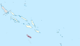 .svg) |
|
Rennell and Bellona (also called Renbel ) is a province of the Solomon Islands , which is formed by the islands of Rennell and Bellona and a group of three uninhabited atolls ( Indispensable Reefs ). The Polynesians named the main islands Mu Nggava and Mu Ngiki . Both islands are mostly inhabited by Polynesians. Rennell is one of the southernmost islands in the Solomon Islands.
The island of Renbel Province covers an area of 671 km². After the census of 2009 there lived 3006 people.
The atolls were officially discovered by Mathew Boyd of Camberwell , an Englishman and captain of the merchant ship Bellona in 1793.


Individual evidence
- ↑ Solomon Islands Broadcasting Corporation ( Memento of the original from February 16, 2011 in the Internet Archive ) Info: The archive link was automatically inserted and not yet checked. Please check the original and archive link according to the instructions and then remove this notice.
- ↑ PopGIS 2.0 Solomon Islands
Central | Choiseul | Guadalcanal | Isabel | Makira and Ulawa | Malaita | Rennell and Bellona | Temotu | Western | Honiara (capital district)