
Choiseul (province)
| Choiseul | |
|---|---|

|
|
| geography | |
| Country: | Solomon Islands |
| Waters: | Pacific Ocean |
| Islands: | Choiseul , Vaghena , Rob Roy and Taro Island and others small. Islands |
| Geographical location: | 7 ° 1 ′ S , 156 ° 57 ′ E |
| Basic data | |
| Surface: | 3837 km² |
| Residents: | 26,380 |
| Population density: | 7 inhabitants / km² |
| Capital: | taro |
| Situation map | |
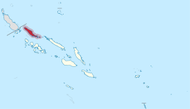 .svg) |
|

The Choiseul Province is one of 9 provinces in the Solomon Islands . The province comprising four islands is located between the islands of Bougainville and Santa Isabel in the west of the Solomon Islands and has a total area of 3,837 km² and had 26,380 inhabitants in 2009. The highest point is Mount Maetabe at 1,060 m in the central highlands of Choiseul.
The following islands belong to the Choiseul Province:
- Choiseul ( also Lauru ) (3,294 km²), 11,000 inhabitants, capital : Malevangga (other names: Malabague, Malivaga, Maleva, Malevaga, Malivanga, Malivugu)
- Vaghena ( also Wagina ) (243 km²), 1,000 inhabitants, capital: Vaghena
- Rob Roy (60 km²), uninhabited
- other smaller islands such as Taro Island (0.4 km²), 440 inhabitants (as of 1999), seat of the provincial capital Taro
The capital of the Choiseul Province is Taro .
Discovery and origin of name
When the Spanish navigator Alvaro de Mendaña de Neyra discovered this island in 1568, he named it San Marcos. After that, it was forgotten. It was not until 200 years later that the French explorer Louis Antoine de Bougainville landed on this island and named it after the French foreign minister and statesman at the time, Choiseul.
Culture
population
The population is made up of several Melanesian tribes, including the Gilbertese who live on the southernmost island of Vaghena . Headhunting and the slave trade were widespread in the 19th century . This resulted in Wagina Island becoming uninhabited in the 1870s. At the beginning of the 20th century, the Choiseul islanders were notorious cannibals , so visitors only came to these islands armed. In 1916 there were cruel tribal wars, which were only ended on August 8, 1921 by the peace treaty of Sasamungga. This event is known as "Kulabule" and is now a holiday on Choiseul. Many islanders live in simple wooden houses and live from the cultivation of betel nuts .
Soccer
The residents of Choiseul are enthusiastic about football. Your soccer team is called Lauru Kuvojo. In 2005 they took part in the Solomon Cup, the national soccer championship of the Solomon Islands. However, they were eliminated in the preliminary round.
Flora and fauna
Choiseul has a flora and fauna that is shaped by both New Guinea and Australia. The largest mammal is the critically endangered dugong , a manatee found primarily in the waters off Rob Roy. The largest reptile is the estuarine crocodile (Crocodylus porosus) known from Australia . Birds here include the reef freon (Egretta sacra), the eyebrow duck (Anas superciliosa) and the Solomon sea eagle (Haliaeetus sanfordi). Until the beginning of the 20th century also the now extinct lived Choiseul Pigeon ( Microgoura meeki ), which today adorns the flag of the Choiseul Province. There is also an important breeding site for the hawksbill sea turtle on Choiseul . The flora is mainly represented by mangrove forests and coconut plantations.
Web links
- Map of Malevangga
- Information about Choiseul
- History of Choiseul ( PDF file; 159 kB)
Individual evidence
Central | Choiseul | Guadalcanal | Isabel | Makira and Ulawa | Malaita | Rennell and Bellona | Temotu | Western | Honiara (capital district)