Choiseul (island)
| Choiseul | |
|---|---|
| Satellite image of Choiseul | |
| Waters | Pacific Ocean |
| Archipelago | Solomon Islands |
| Geographical location | 7 ° 0 ′ S , 156 ° 58 ′ E |
| length | 144 km |
| width | 23 km |
| surface | 3 294 km² |
| Highest elevation |
Mount Maetambe 1067 m |
| Residents | 20,000 (1999) 6.1 inhabitants / km² |
| main place | Malevangga |
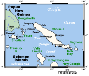
| Map of Choiseul | |
The island of Choiseul , traditionally called Lauru , is located in the northern province of the same name in the Pacific island state of the Solomon Islands . It borders in the south on the Solomon Islands Santa Isabel and in the north on the island of Bougainville ( Papua New Guinea ).
Choiseul is one of the largest in the Solomon Islands . The elongated island has a land area of 3,294 km²; The highest point is Mount Maetambe at 1,067 m in the densely forested interior of the island. The eastern tip of the island, discovered by the French navigator Surville in 1769 , was formerly named Cap Labé by Admiral von Krusenstern after an officer of Surville .
With the Samoa Treaty (1899) the Germans renounced their rights to parts of the Southern Solomon Islands . This made Choiseul, which had been part of German New Guinea since 1885 , colonial possession of Great Britain .
In 1999 Choiseul had around 20,000 inhabitants. They mostly live in smaller villages on the west and east coasts; The main town is Malevangga in the north.
history
In 1568 the Spanish navigator Alvaro de Mendaña de Neyra sighted a large island northwest of Santa Isabel, which he called San Marcos . However, he did not land on the island, which was most likely Choiseul. Due to a mapping error, it was not rediscovered for Europe until 1768 by the French researcher Louis Antoine de Bougainville . He named it after the then French Foreign Minister Étienne-François de Choiseul . The island belonged to German New Guinea from 1886 to the Samoa Treaty of 1899 . Then she went to Great Britain.
Together with the islands of Taro , Vaghena and Rob Roy, Choiseul forms a province of the state of Solomon Islands, which has been independent since 1978 .
Individual evidence
- ^ Johann Jakob Egli : Nomina geographica. Language and factual explanation of 42,000 geographical names of all regions of the world. , Friedrich Brandstetter, 2nd ed. Leipzig 1893, p. 519
- ↑ http://www.ub.bildarchiv-dkg.uni-frankfurt.de/Bildprojekt/Lexikon/php/suche_db.php?suchname=Salomoninseln
- ↑ Choiseul , in: Heinrich Schnee (Hrsg.): German Colonial Lexicon . Volume III, Quelle & Meyer, Leipzig 1920, p. 273.


