
Central (Solomon Islands)
| Central Province | |
|---|---|

|
|
| geography | |
| Country: | Solomon Islands |
| Waters: | Pacific Ocean |
| Islands: | Russell Islands , Nggela Islands and Savo Island |
| Geographical location: | 9 ° 4 ′ S , 160 ° 13 ′ E |
| Basic data | |
| Surface: | 615 km² |
| Residents: | 26,051 (2009) |
| Population density: | 42 inhabitants / km² |
| Capital: | Tulagi |
| Situation map | |
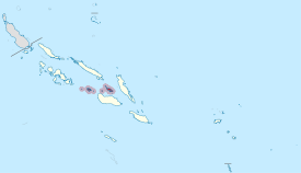 .svg) |
|
The small province of Central is located in the center of the Pacific island state of Solomon Islands . It borders on the province of Guadalcanal in the south .
The province of Central consists of the island groups Nggela (formerly Florida Islands) and Russell Islands , as well as the individual island Savo Iceland .
The provincial capital Tulagi is located on the island of the same name ( Tulagi ), which is 1.5 kilometers off the southwest coast of Nggela Sule (Florida Island).
The area of the islands of the Central Province amounts to 615 km². After the census of 2009 there were living 26,051 people.
See also
Individual evidence
Web links
Central | Choiseul | Guadalcanal | Isabel | Makira and Ulawa | Malaita | Rennell and Bellona | Temotu | Western | Honiara (capital district)