Bass Islands
| Bass Islands | ||
|---|---|---|
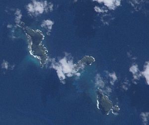
| NASA image of the Bass Islands | ||
| Waters | Coral sea | |
| archipelago | Duff Islands | |
| Geographical location | 9 ° 56 ′ S , 167 ° 14 ′ E | |
|
|
||
| Number of islands | 3 | |
| Main island | Lua | |
| Residents | uninhabited | |
| Isle de Baſs right on map by James Wilson (1799) | ||
The Bass Islands are a subordinate group in the south of the Duff Islands of the island state of the Solomon Islands in the Pacific .
geography
The group consists of three or four small rock islands (from north to south):
- Lua (with a very small, unnamed rock island in front of it to the north)
- Kaa
- Loreva Island
All islands are uninhabited.
history
On the handwritten nautical chart of James Wilson , captain of the mission ship Duff of the London Missionary Society , from 1799 the Bass Islands are first verifiably mentioned, as Isle de Baſs , with the reference to the entire Duff archipelago Diſcovered September 25 , 1797 .


