
Iwaki
| Iwaki-shi い わ き 市 |
|||
|---|---|---|---|
 |
|||
| Geographical location in Japan | |||
|
|||
| Region : | Tōhoku | ||
| Prefecture : | Fukushima | ||
| Coordinates : | 37 ° 3 ' N , 140 ° 53' E | ||
| Basic data | |||
| Surface: | 1,231.34 km² | ||
| Residents : | 338,045 (April 1, 2020) |
||
| Population density : | 275 inhabitants per km² | ||
| Community key : | 07204-4 | ||
| Symbols | |||
| Flag / coat of arms: |
 |
||
| Tree : | Japanese black pine | ||
| Flower : | azalea | ||
| Bird : | Common gull | ||
| Fish : | Chlorophthalmus albatrossis | ||
| town hall | |||
| Address : |
Iwaki City Hall 21 , Aza Umemoto, Taira Iwaki -shi Fukushima 970-8686 |
||
| Website URL: | http://www.city.iwaki.fukushima.jp/ | ||
| Location of Iwakis in Fukushima Prefecture | |||
 |
|||

Iwaki ( Japanese い わ き 市 , -shi ) is a city in Fukushima Prefecture on Honshū , the main island of Japan . Iwaki is on the edge of the Fukushima Exclusion Zone. The city used to have 350,000 inhabitants, but after the Fukushima nuclear disaster , many people moved away for fear of exposure to radioactive substances.
geography


Iwaki is located about 200 km northeast of Tokyo on the coast of the Pacific Ocean at the mouth of the Iwaki River of the same name.
history
Iwaki was created on October 1, 1966 through the merger of the cities of Uchigō ( 内 郷 市 ), Iwaki ( 磐 城市 ), Jōban ( 常 磐 市 ), Nakoso ( 勿 来 市 ) and Taira ( 平 市 ), as well as another 4 communities and 5 villages in the Iwaki districts and Futaba .
2011 Tōhoku earthquake
On March 11, 2011, the city was hit by the Tōhoku earthquake and the subsequent tsunami. The number of completely destroyed residential buildings is put at 4644 and that of the partially destroyed at 32,921.
The Fire and Disaster Management Agency (FDMA) reported 303 dead and 82 missing persons in its damage report on May 19. After the damage was recorded, the number of deaths counted increased to 436, while 37 people were still missing.
As a countermeasure to the nuclear disaster, a restricted area was designated around the Fukushima Daiichi nuclear power plant within a radius of 20 km. However, there were also many other locations with high radiation values beyond this 20 km radius, as radioactive particles were carried away from the damaged power plant by the wind. These locations included 11 villages and cities, including Minamisōma , Naraha , Tomioka , Kawauchi , Ōkuma , Futaba , Namie , Katsurao , Iitate , Tamura and Kawamata . According to the evacuation orders of May 7, 2013, these regions were divided into four different categories according to their radioactive exposure: Areas with a radiation exposure of less than 20 mSv per year, which were treated by the government as a threshold value for permanent return Category 1. Areas of this Category 1 could be entered at their own discretion and without the use of protective equipment with the only restriction that they were not allowed to stay overnight there. These areas were ready for the evacuation order to be lifted. In areas with a radiation exposure between 20 and 50 mSv per year (category 2), residents were prohibited from permanent residence. Areas with over 50 mSv per year (category 3) were seen as unsuitable for a return of residents in the long term. A fourth evacuation area had a special status.
The city of Iwaki is an example of host communities for evacuees where TEPCO's government support programs and compensation payments have been accompanied by conflicts between evacuees and their host community. People in the Iwaki host community, who themselves suffered the effects of the tsunami and earthquake without receiving compensation, developed a hostile attitude towards those evacuated from the Futaba nuclear disaster , who had received compensation. The city of Iwaki, which, in addition to the consequences of the earthquake and tsunami, also carried the burden of accommodating around 24,000 evacuees from other affected communities, asked the Japanese government for additional financial support to strengthen the public service for the evacuees.
- Gallery: Effects in Iwaki after the earthquake and tsunami of March 11, 2011:
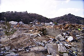
Destruction after the tsunami in Iwaki (Photo: March 31, 2011)

Destruction in the port of Onahama (Photo: March 29, 2011)
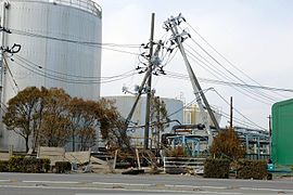
Tilted electricity pylons in the port of Onahama (Photo: March 29, 2011)

Tsunami rubble in Iwaki (Photo: March 10, 2012)


traffic
- Streets:
- Jōban Highway
- National road 6 : to Tōkyō or Sendai
- National road 49: to Niigata
- Train:
- JR Jōban line : to Ueno or Sendai
- JR Banetsu East Line : to Kōriyama
economy
Today Iwaki is a modern industrial center, where machines and wood products and chemical products are produced.
Alpine Electronics has its development center in Iwaki.
Neighboring cities and communities
sons and daughters of the town
- Mitsuhide Iwaki (* 1949), politician, 1990–1997 mayor of the city of Iwaki
- Misaki Itō (born 1977), actress
- Eigo Satō (1978-2013), freestyle motocross pilot
- Takuya Komine (* 1988), football player
Individual evidence
- ↑ a b 平 成 23 年 (2011 年) 東北 地方 太平洋 沖 地震 (東 日本 大 震災) に つ い て (第 157 報) ( Memento of March 18, 2018 on WebCite ) ( PDF ( Memento of March 18, 2018 on WebCite )), 総 務省 消防 庁 (Fire and Disaster Management Agency), March 7, 2018.
- ↑ 平 成 23 年 (2011 年) 東北 地方 太平洋 沖 地震 (第 124 報) ( Memento from March 25, 2018 on WebCite ) ( PDF ( Memento from March 25, 2018 on WebCite )), 総 務 省 消防 庁 (Fire and Disaster Management Agency), 124th report, May 19, 2011.
- ↑ 東 日本 大 震災 図 説 集 . (No longer available online.) In: mainichi.jp. Mainichi Shimbun- sha, May 20, 2011, archived from the original on June 19, 2011 ; Retrieved June 19, 2011 (Japanese, overview of reported dead, missing and evacuated).
- ↑ 平 成 23 年 (2011 年) 東北 地方 太平洋 沖 地震 (東 日本 大 震災) に つ い て (第 153 報) ( Memento of March 10, 2016 on WebCite ) , 総 務 省 消防 庁 (Fire and Disaster Management Agency), March 8, 2016 .
- ↑ Dinil Pushpalal, Zhang Yan, Tran Thi Diem Thi, Yuri Scherbak, Michiko Kohama: Tears of Namie: An Appraisal of Human Security in the Township of Namie . In: Dinil Pushpalal, Jakob Rhyner, Vilma Hossini (eds.): The Great Eastern Japan Earthquake 11 March 2011: Lessons Learned And Research Questions - Conference Proceedings (11 March 2013, UN Campus, Bonn) . 2013, ISBN 978-3-944535-20-3 , ISSN 2075-0498 , pp. 80-87 .
- ^ The Recovery Process in Fukushima . In: Federica Ranghieri, Mikio Ishiwatari (Ed.): Learning from Megadisasters - Lessons from the Great East Japan Earthquake . World Bank Publications, Washington, DC 2014, ISBN 978-1-4648-0153-2 , Chapter 36, pp. 331–343 , doi : 10.1596 / 978-1-4648-0153-2 ( limited preview in Google book search). , License: Creative Commons Attribution CC BY 3.0 IGO.
Web links
- 10 万分 1 浸水 範 囲 概況 図 , 国土 地理 院 ( Kokudo Chiriin , Geospatial Information Authority of Japan, formerly: Geographical Survey Institute = GSI), www.gsi.go.jp: 地理 院 ホ ー ム> 防災 関 連> 平 成 23 年 (2011年) 東北 地方 太平洋 沖 地震 に 関 す る 情報 提供> 10 万分 1 浸水 範 囲 概況 図:
- The GSI published here two maps with Iwaki ( 浸水範囲概況図16 , 浸水範囲概況図17 ) on which the 2011 flooded the Tōhoku tsunami areas are drawn on the basis of reports of aerial photographs and satellite imagery, as far as was possible.

Independent cities ( shi ): Aizu-Wakamatsu | Date | Fukushima (administrative headquarters) | Iwaki | Kitakata | Kōriyama | Minamisōma | Motomiya | Nihonmatsu | Shirakawa | Sōma | Sukagawa | Tamura
Adachi-gun : Ōtama | Date-gun : Kawamata | Koori | Kunimi | Futaba-gun : Futaba | Hirono | Katsurao | Kawauchi | Namie | Naraha | Ōkuma | Tomioka | Higashishirakawa-gun : Hanawa | Samegawa | Tanagura | Yamatsuri | Ishikawa-gun : Asakawa | Furudono | Hirata | Ishikawa | Tamakawa | Iwase-gun : Kagamiishi | Ten'ei | Kawanuma-gun : Aizubange | Yanaizu | Yugawa | Minamiaizu-gun : Hinoemata | Minamiaizu | Shimogō | Tadami | Nishishirakawa-gun : Izumizaki | Nakajima | Nishigō | Yabuki | Ōnuma-gun : Aizumisato | Kaneyama | Mishima | Shōwa | Sōma-gun : Iitate | Shinchi | Tamura-gun : Miharu | Ono | Yama-gun : Bandai | Inawashiro | Kitashiobara | Nishiaizu