Kosrae
| Kosrae (Kusaie) | ||
|---|---|---|
| Overview map | ||
| Waters | Pacific Ocean | |
| Archipelago | Carolines | |
| Geographical location | 5 ° 19 ′ N , 162 ° 58 ′ E | |
|
|
||
| surface | 108 km² | |
| Highest elevation | Finol Finkol 634 m |
|
| Residents | 6616 (2010) 61 inhabitants / km² |
|
| main place | Tofol | |
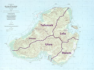
| Topographic map with administrative structure | ||
Kosrae (pronounced [ koˈʃraːeː ], formerly Kusaie , Ualan or Strong ('s) Island ) is an island in the Central Pacific . Together with eight other islands, it forms geographically the group of the same name as the Kosrae Islands and politically the easternmost state of the Federated States of Micronesia .
geography
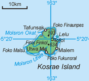
Kosrae is the second largest single island in the Federated States of Micronesia and belongs to the Caroline Archipelago . The main town of the island and the state of Kosrae is the small town of Tofol on the northeast coast. The land area is 108 km² (not including the secondary islands ).
The landscape is hilly and shaped by tropical rainforests . A special feature of the island is that it is the only rocky island in Micronesia to be surrounded by a coral reef . Within this reef there are around eight small side islands . The largest, most important and only inhabited secondary island is Lelu in the bay adjacent to the main town of Tofol. Kosrae's smaller islands, all close to the coast, are Kiul (Gabert), Mutunyal, Sroansak, Srukames, Yen Yen , Yenasr and the airport island .
Flora and fauna
Kosrae is home to the endemic Kosrae flying fox (Pteropus ualanus), whose populations are stable according to the IUCN . There are a total of 36 bird species on Kosrae, with eight species of snipe birds being particularly rich . Two endemic bird species - the Kosrae Moorhen and the Kosrae Singstar - are already extinct.
history
Kosrae was probably born in the 1st millennium BC. Populated from Polynesia . However, an exact determination of the first settlement is not possible because, in contrast to other larger Micronesian islands, no pre-colonial stone buildings have been found. On the island of Lelu to the east, ruins from the 15th century were found.
Since the 16th century Kosrae was officially owned by Spain , in 1898 they became a colony of the German Empire . During the First World War , the island was occupied by Japan .
During the Second World War Kosrae was not attacked directly as part of the island jumping of the USA , but several Japanese ships lying off the coast of the island were sunk, which today are well-preserved wrecks and a tourist attraction.
After the war ended, Kosrae became part of the US Pacific Islands Trust Territory .
On May 10, 1979, Kosrae ratified the Constitution of the Federated States of Micronesia and became an integral part of this new nation with its official independence on November 3, 1986.
economy
The only significant industry is tourism , the largest employers are government institutions and Kosrae International Airport , which is located on an artificial island off Kosrae's northwest coast.
However, large parts of the population still live mainly from subsistence agriculture .
Web links
- Kosrae Visitor Center ( Memento from December 24, 2001 in the Internet Archive )
- Kosrae Visitor Office
- Photos by Kosrae
Individual evidence
- ↑ IUCN website on Pteropus ualanus (accessed March 23, 2011)
- ↑ Avibase - Bird Checklist Kosrae (accessed March 23, 2011)
- ↑ Website of the US Department of the Interior, National Park Service (English)


