Lelu (island)
| Lelu | ||
|---|---|---|
| Kosrae Islands (Lelu to the east, right) | ||
| Waters | Pacific Ocean | |
| Archipelago | Carolines | |
| Geographical location | 5 ° 19 '56 " N , 163 ° 1' 38" E | |
|
|
||
| length | 1.5 km | |
| width | 700 m | |
| surface | 1 km² | |
| Highest elevation | Finol Poro (Mount Fenkofuru) 109.7 m |
|
| Residents | 1594 (1980) 1594 inhabitants / km² |
|
| main place | Lelu Village | |
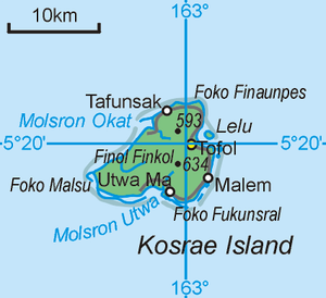
| Topographic map of Lelu Island and the neighboring area of Kosrae Island | ||
Lelu , formerly also Lele , is a Pacific island in the Carolines archipelago .
geography
With just under one square kilometer of land, it is the second largest island in the state of Kosrae , the easternmost member of the Federated States of Micronesia .
An exact current population is not known, as the island is not a separate municipality, but rather large parts of the adjacent mainland of the main island Kosrae u. a. with the place Tofol belong to the municipality of Lelu. The last time a separate population was recorded for the island was in 1980. This was 1594 inhabitants (from 1995 for the municipality and 5491 for Kosrae as a whole including Lele) (for comparison 1970: 1267 of 1650 or 3266). The island's population share of the total state from then 29 percent (1970: 39 percent) has decreased, however, because the island of Kosrae had more space for population growth (7686 for the state of Kosrae in 2000) than the comparatively overpopulated island of Lelu. In comparison, the population of the island of Lelu has hardly increased since 1980.
Lelu is located in a bay less than 500 meters east of Kosrae Island . The island is located within the fringing reef that surrounds Kosrae Island. This opens in the south of the island to Lelu Harbor ( Molsron Lelu ). Lelu is 1.5 km long and up to 700 m wide. The flat western part of the island is populated, the eastern part hardly, but densely forested and hilly. The highest point on the island is Finol Poro (Mount Fenkofuru) in the east, with a height of 110 meters.
The island is connected to the northeast coast of Kosrae Island by a 650 m long artificial roadway.
The main town of Lelu is Lelu Village on the northwest coast. About 80 meters to the northeast is the uninhabited island of Yen Yen , and about 400 meters to the north is the even smaller island of Yenasr .
administration
The island of Lelu belongs to the Kosrae community of the same name, Lelu . This municipality also includes large parts of the east of the island of Kosrae (with a total municipality area of 21.5 km²), in particular the place Tofol , the capital of the state of Kosrae.
history
In 1970 the island was still a separate administrative district within Kosrae (then a municipality of the Ponape district, now the state of Pohnpei). The eastern part of the island of Pohnpei, which has belonged to the municipality of Lelu since the municipality was divided, was then known as the Yepen district (today the area around the Tofol district ).
Lelu has traditionally been the center of the neighboring main island of Kosrae for centuries. This is evidenced by ruins from 1400, when the residents of Lelu conquered the main island and united it politically.
Individual evidence
- ↑ Number of Inhabitants, Trust Territory of the Pacific Islands (PDF; 3.3 MB)
- ↑ 1970 census Trust Territory (PDF; 5.2 MB)
- ↑ [1] (PDF; 5.4 MB) Kosrae Census 2000
- ↑ The Lelu Ruins ( Memento of the original from December 14, 2009 in the Internet Archive ) Info: The archive link was automatically inserted and not yet checked. Please check the original and archive link according to the instructions and then remove this notice.
- ↑ Lelu Ruins, Island of Kosrae, Micronesia


