Takahagi
| Takahagi-shi 高 萩 市 |
||
|---|---|---|
| Geographical location in Japan | ||
|
|
||
| Region : | Kanto | |
| Prefecture : | Ibaraki | |
| Coordinates : | 36 ° 43 ' N , 140 ° 43' E | |
| Basic data | ||
| Surface: | 193.65 km² | |
| Residents : | 27,863 (October 1, 2019) |
|
| Population density : | 144 inhabitants per km² | |
| Community key : | 08214-7 | |
| Symbols | ||
| Flag / coat of arms: | ||
| Tree : | jaw | |
| Flower : | Hagi shrub | |
| Bird : | Colored pheasant | |
| town hall | ||
| Address : |
Takahagi City Hall 1 - 100 - 1 , Hon-chō Takahagi -shi Ibaraki 318-8511 |
|
| Website URL: | http://www.city.takahagi.ibaraki.jp | |
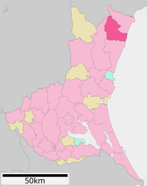
| Location of Takahagis in Ibaraki Prefecture | ||
Takahagi ( Japanese 高 萩 市 , -shi ) is a city in Ibaraki Prefecture in Japan .
geography
Takahagi is north of Hitachi and south of Iwaki .
history
The city was founded on November 23, 1954 .
The natural disaster of the Tōhoku earthquake on March 11, 2011 with the subsequent tsunami claimed a death in Takahagi. 142 residential buildings were completely destroyed and 1,041 others were partially destroyed.
traffic
- Train:
- Street:
Neighboring cities and communities
Web links
Commons : Takahagi - collection of images, videos and audio files
Individual evidence
- ↑ 平 成 23 年 (2011 年) 東北 地方 太平洋 沖 地震 (東 日本 大 震災) に つ い て (第 157 報) ( Memento of March 18, 2018 on WebCite ) ( PDF ( Memento of March 18, 2018 on WebCite )), 総 務 省 消防庁 (Fire and Disaster Management Agency), 157th report, March 7, 2018.


