Hitachi-Ōta
| Hitachi-Ōta-shi 常 陸太田 市 |
||
|---|---|---|
| Geographical location in Japan | ||
|
|
||
| Region : | Kanto | |
| Prefecture : | Ibaraki | |
| Coordinates : | 36 ° 32 ' N , 140 ° 32' E | |
| Basic data | ||
| Surface: | 372.01 km² | |
| Residents : | 48,758 (October 1, 2019) |
|
| Population density : | 131 inhabitants per km² | |
| Community key : | 08212-1 | |
| Symbols | ||
| Flag / coat of arms: | ||
| Tree : | Japanese zelkove | |
| Flower : | Kerrie | |
| Bird : | kingfisher | |
| town hall | ||
| Address : |
Hitachiota City Hall 3690 Kanai-cho Hitachiōta shi Ibaraki 315-8640 |
|
| Website URL: | http://www.city.hitachiota.ibaraki.jp | |
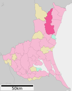
| Location Hitachi-Ōtas in Ibaraki Prefecture | ||
Hitachi-Ōta ( Japanese 常 陸太田 市 , -shi ) is a city in Japan in Ibaraki Prefecture .
geography
Hitachi-Ōta is west of Hitachi and north of Mito .
history
Hitachi-Ōta had been a castle town since the 12th century. The castle was mainly used by the Sataks in the Middle Ages . After 1600 the castle was abandoned. Ōta was promoted to city on July 15, 1954 .
Attractions
traffic
- Train:
- Street:
- Joban Highway
- National Road 293,349
Neighboring cities and communities
Web links
Commons : Hitachi-Ōta - collection of images, videos and audio files
- Official Website (Japanese)


