Moriya
| Moriya-shi 守 谷 市 |
||
|---|---|---|
| Geographical location in Japan | ||
|
|
||
| Region : | Kanto | |
| Prefecture : | Ibaraki | |
| Coordinates : | 35 ° 57 ' N , 139 ° 59' E | |
| Basic data | ||
| Surface: | 35.63 km² | |
| Residents : | 67,696 (October 1, 2019) |
|
| Population density : | 1900 inhabitants per km² | |
| Community key : | 08224-4 | |
| Symbols | ||
| Flag / coat of arms: | ||
| Tree : | jaw | |
| Flower : | Lilium auratum | |
| Bird : | Bambusicola thoracicus | |
| town hall | ||
| Address : |
Moriya City Hall 950 - 1 , Ōgashiwa Moriya -shi Ibaraki 302-0100 |
|
| Website URL: | http://www.city.moriya.ibaraki.jp/ | |
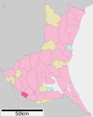
| Location of Moriyas in Ibaraki Prefecture | ||
Moriya ( Japanese 守 谷 市 , - shi ) is a city ( Shi ) in Ibaraki Prefecture in Japan .
geography
Moriya is located about 35 km north of the capital Tokyo, southwest of Tsukuba and north of Kashiwa . The Tone River (利 根 川, Tone-gawa ) flows through the city from southwest to southeast. In addition, the rivers Kokai (小 貝川, Kokai-gawa ) in the northeast and Kinu (鬼怒川, Kinu-gawa ) in the west flow through Moriya.
history
Moriya was named a city ( Shi ) on February 2, 2002 .
economy
There are several industrial areas in Moriya. In addition, the city is a satellite city for commuters who work in the greater Tokyo area.
education
There are nine public elementary schools, four middle schools and one high school in Moriya.
Attractions
In the east of the city is the "Moriya Wild Bird Trail" (守 谷 野鳥 の み ち, yachō no michi).
traffic
- Street:
- National Road 294 to Kashiwa or Aizuwakamatsu
- Rail:
- Tsukuba Express to Tsukuba (Ibaraki) or Akihabara ( Tokyo )
- Kantō Tetsudō Jōsō line to Shimodate (Ibaraki) or Toride (Ibaraki)
Town twinning
-
 Mainburg , since 1990
 -
 Greeley, Colorado , since 1993
Neighboring cities and communities
- Ibaraki prefecture
- Chiba prefecture
Personalities
- Takafumi Suzuki (* 1987), football player


