Tsuchiura
| Tsuchiura-shi 土 浦 市 |
||
|---|---|---|
| Geographical location in Japan | ||
|
|
||
| Region : | Kanto | |
| Prefecture : | Ibaraki | |
| Coordinates : | 36 ° 4 ' N , 140 ° 12' E | |
| Basic data | ||
| Surface: | 113.82 km² | |
| Residents : | 138,517 (October 1, 2019) |
|
| Population density : | 1217 inhabitants per km² | |
| Community key : | 08203-1 | |
| Symbols | ||
| Flag / coat of arms: | ||
| Tree : | Poplar , Japanese zelkove | |
| Flower : | Cherry Blossom | |
| Bird : | Great Reed Warbler , Japanese Bush Warbler | |
| town hall | ||
| Address : |
Tsuchiura City Hall 1 - 20 - 35 , Shimotakatsu Tsuchiura -shi Ibaraki 300-0812 |
|
| Website URL: | http://www.city.tsuchiura.lg.jp/index.html | |
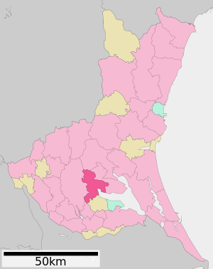
| Location of Tsuchiuras in Ibaraki Prefecture | ||
Tsuchiura ( Japanese 土 浦 市 , - shi ) is a city in the south of Ibaraki Prefecture on Honshū , the main island of Japan .
geography
Tsuchiura is located on the second largest lake in Japan, the 220 km² Kasumigaura .
Tsuchiura is 64 km from Tōkyō .
history
One of the old temples in Tsuchiura is Kiyotaki-ji , located on the northern edge of the city . It is the 26th of the 33 temples in the Kanto region .
The first written mention of the place took place in 1329. Tsuchiura Castle was built during the Muromachi period (1333–1568) . The Tsuchiya last resided there until the Meiji Restoration .
Attractions
traffic
- Street:
- Jōban highway to Tōkyō or Iwaki
- National road 6 to Tōkyō or Sendai
- Train:
- JR Jōban Line to Tōkyō and Sendai
Personalities
- Kikuji Kawada (* 1933), photographer
- Jun'ichi Saga (born 1941), writer
- Miri Yū (* 1968), writer
- Chiaki Kuriyama (* 1984), actress and singer
Town twinning
-
 Friedrichshafen , since 1994
Neighboring cities and communities
Web links
Commons : Tsuchiura - collection of images, videos and audio files


