Tōkai (Ibaraki)
| Tōkai-mura 東海 村 |
||
|---|---|---|
|
|
||
| Geographical location in Japan | ||
| Region : | Kanto | |
| Prefecture : | Ibaraki | |
| Coordinates : | 36 ° 28 ' N , 140 ° 34' E | |
| Basic data | ||
| Surface: | 37.48 km² | |
| Residents : | 37,702 (October 1, 2019) |
|
| Population density : | 1006 inhabitants per km² | |
| Community key : | 08341-1 | |
| Symbols | ||
| Flag / coat of arms: | ||
| Tree : | Japanese black pine | |
| Flower : | Lilium maculatum | |
| Bird : | Japan spectacled bird | |
| town hall | ||
| Address : |
Tōkai Village Hall 3 - 7 - 1 , Tōkai Tōkai -mura, Naka-gun Ibaraki 319-1192 |
|
| Website URL: | http://www.vill.tokai.ibaraki.jp | |
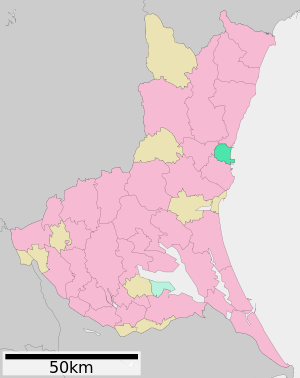
| Location Tōkais in Ibaraki Prefecture | ||
Tōkai ( Japanese 東海 村 - mura ) is a village about 120 km north of Tokyo , in the district of Naka in Ibaraki Prefecture in Japan .
geography
Tōkai lies between the two rivers Kujigawa (Japanese 慈 川) in the north and Shinkawa (Japanese 新 川) in the south. The northern part along the Kuji and the lowland area in the east consist of alluvial land, which is also used for rice cultivation. The plateau is 20 to 30 meters above sea level; dry alluvial areas and lowland forests extend to the east with a gentle slope towards the Pacific.
history
The natural disaster of the Tōhoku earthquake on March 11, 2011 with the subsequent tsunami claimed six deaths in Tōkai. 28 residential buildings were completely destroyed and 158 others were partially destroyed.
Nuclear industry
The Tōkai nuclear power plant and the national reprocessing plant for spent fuel elements from nuclear power plants are located in Tōkai . Together with other facilities and institutes, it forms a large nuclear complex. Construction of the reprocessing plant, which is designed for an annual throughput of 210 t, began in 1971. The hot trial operation began in September 1977, and full commissioning took place in January 1981. It was planned at an early stage to use the experience gained in Tōkai for the construction and operation of a commercial plant. This is currently under construction in Rokkasho . The facility in Tōkai is to take on more research and development tasks in the future.
On March 11, 1997, a fire in the solidification plant caused the worst nuclear accident in Japan to date. 37 workers were contaminated . One week later , in the city of Tsukuba , 60 kilometers away , “drastically increased levels of the radioactive gamma emitter cesium in rainwater” were found. The loud Georg Blume time "influential politicians" Japan's Seiroku Kajiyama ( LDP ) said: "We have set long too much confidence in the nuclear industry for over forty years. '" The accident was finally to level three of the international scale for nuclear events qualified.
On September 30, 1999, the Tōkaimura nuclear accident occurred in the fuel element factory of the Japan Nuclear Fuel Concersion Company . When filling a nitric acid tank with approx. 16 kg of highly enriched uranium oxide , the criticality was exceeded and a nuclear chain reaction occurred. At least 150 people were exposed to high levels of radioactivity, including 81 workers trying to stop the chain reaction. Two of them who filled the tank when the criticality incident occurred died as a result of the radiation dose. Several hundred residents were exposed to the radiation. The accident is classified at level 4 on the international rating scale for nuclear incidents .
Town twinning
-
 Idaho Falls , Idaho , USA
Sons and daughters of the village
- Masaru Hashimoto (* 1945), Governor of the Ibaraki Prefecture
Neighboring cities and communities
See also
- Nuclear energy in japan
- Japanese Nuclear Regulatory Agency
- List of nuclear facilities
- List of accidents in nuclear facilities
Web links
- Official Website (Japanese, English, Chinese, Korean)
Individual evidence
- ↑ 平 成 23 年 (2011 年) 東北 地方 太平洋 沖 地震 (東 日本 大 震災) に つ い て (第 157 報) ( Memento of March 18, 2018 on WebCite ) ( PDF ( Memento of March 18, 2018 on WebCite )), 総 務 省 消防庁 (Fire and Disaster Management Agency), 157th report, March 7, 2018.
- ↑ Georg Blume: The Tokaimura Fanal. Zeit online, March 21, 1997, accessed February 20, 2017 .
- ↑ The international nuclear and radiological event scale (PDF)


