Mutsu (Aomori)
| Mutsu-shi む つ 市 |
||
|---|---|---|
| Geographical location in Japan | ||
|
|
||
| Region : | Tōhoku | |
| Prefecture : | Aomori | |
| Coordinates : | 41 ° 18 ' N , 141 ° 12' E | |
| Basic data | ||
| Surface: | 863.79 km² | |
| Residents : | 54,721 (June 1, 2019) |
|
| Population density : | 63 inhabitants per km² | |
| Community key : | 02208-0 | |
| Symbols | ||
| Flag / coat of arms: | ||
| Tree : | Hiba tree of life | |
| Flower : | Potato rose | |
| Bird : | Whooper swan | |
| town hall | ||
| Address : |
Mutsu City Hall 1 - 1 - 1 , Kanaya Mutsu -shi Aomori 035-8686 |
|
| Website URL: | http://www.mutsu.e-shimokita.jp | |
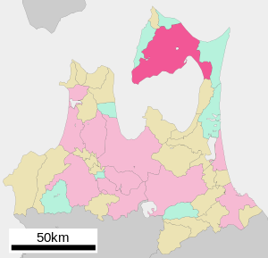
| Location of Mutsu in Aomori Prefecture | ||
Mutsu ( Japanese む つ 市 , - shi ) is a city in Aomori Prefecture on Honshū , the main island of Japan .
geography
Mutsu is located north of Aomori on the Shimokita Peninsula on Mutsu Bay and the Tsugaru Strait .
history
Mutsu was founded on September 1, 1959 as Ōminato-Tanabu ( 大 湊 田 名 部 市 , -shi ) from the union of the two communities Ōminato ( 大 湊 町 , -machi ) and Tanabu ( 田 名 部 町 , -machi ) in Shimokita County. With 6 characters it was the longest name of a city in Japan with 7 characters until Ichiki-Kushikino ( い ち き 串 木 野 市 ) was founded in 2003. With 9 Moren it still holds the record for the longest city name after Moren. On August 1, 1960, the name was changed to Mutsu ( む つ 市 ). It was the first city whose name was written with Hiragana instead of completely with Kanji (see also Japanese toponyms in Kana ).
On March 14, 2005, the communities of Kawauchi ( 川 内 町 , -machi ), Ōhata ( 大 畑 町 , -machi ) and the village of Wakinosawa ( 脇 野 沢 村 , -mura ) were incorporated from Shimokita County.
traffic
- Train:
- Street:
- National road 279, 338
Town twinning
-
 Port Angeles , since 1995
sons and daughters of the town
- Ryū Fujisaki (* 1971), Mangaka , illustrator
- Ken'ichi Matsuyama (* 1985), actor


