Kuroishi
| Kuroishi-shi 黒 石 市 |
||
|---|---|---|
|
|
||
| Geographical location in Japan | ||
| Region : | Tōhoku | |
| Prefecture : | Aomori | |
| Coordinates : | 40 ° 39 ' N , 140 ° 36' E | |
| Basic data | ||
| Surface: | 216.96 km² | |
| Residents : | 32,376 (June 1, 2019) |
|
| Population density : | 149 inhabitants per km² | |
| Community key : | 02204-7 | |
| Symbols | ||
| Flag / coat of arms: | ||
| Tree : | maple | |
| Flower : | Malus pumila var. Domestica | |
| Bird : | Motacilla grandis | |
| town hall | ||
| Address : |
Kuroishi City Hall 11 - 1 , Ichinomachi Kuroishi -shi Aomori 036-0396 |
|
| Website URL: | http://www.city.kuroishi.aomori.jp/ | |
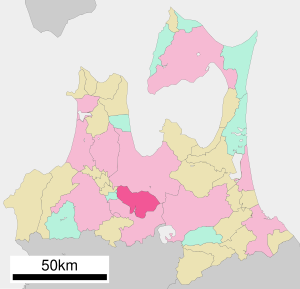
| Location Kuroishis in Aomori Prefecture | ||
Kuroishi ( Japanese 黒 石 市 , - shi ) is a city in Aomori Prefecture on Honshū , the main island of Japan .
geography
Kuroishi is south of Aomori and east of Hirosaki .
history
The city of Kuroishi was founded on July 1, 1954 from the merger of the Kuroishi community ( Gemeinde 石 町 , -machi ) and 4 villages ( 4 郷 村 , 六 郷 村 , 山形 村 and 浅 瀬 石村 ) in Minamitsugaru County.
Town twinning
-
 Yeongcheon , since 1984
traffic
- Street:
- Tōhoku Highway
- National roads 102, 394
- Train:
Neighboring cities and communities
Web links
Commons : Kuroishi - collection of pictures, videos and audio files


