Narita
| Narita-shi 成 田 市 |
||
|---|---|---|
| Geographical location in Japan | ||
|
|
||
| Region : | Kanto | |
| Prefecture : | Chiba | |
| Coordinates : | 35 ° 47 ' N , 140 ° 19' E | |
| Basic data | ||
| Surface: | 213.84 km² | |
| Residents : | 132,293 (October 1, 2019) |
|
| Population density : | 619 inhabitants per km² | |
| Community key : | 12211-4 | |
| Symbols | ||
| Flag / coat of arms: | ||
| Tree : | Ume | |
| Flower : | Garden hydrangea | |
| town hall | ||
| Address : |
Narita City Hall 760 Hanazaki-chō Narita -shi Chiba 286-0033 |
|
| Website URL: | http://www.city.narita.chiba.jp | |
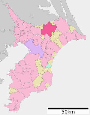
| Location Naritas in Chiba Prefecture | ||
Narita ( Jap. 成田市 , -shi ) is a city in the prefecture of Chiba in Japan in close proximity to Tokyo . Tokyo-Narita International Airport is also located here , with many flights to Europe , Asia and Australia .
Historical
Stone tools found by archaeologists in today's urban area are evidence of early settlements that can be dated back up to 30,000 years. There are also numerous clams from the Jōmon period , as well as hundreds of Kofun (burial mounds) from the Kofun period . Even if the first mention by name was made in 1409, places in the surrounding area were already mentioned in the Man'yōshū of the Nara period .
Thanks to its advantageous location on the Pacific coast, surrounded by numerous small rivers, and its proximity to Tokyo Bay , Narita has developed into a regional center for politics and trade. The city gained additional importance through the establishment of the Buddhist temple Narita-san Shinshō-ji in 940. During the Heian period , Narita was the center of the uprising of the samurai Taira no Masakado . In the Edo period , Narita began to flourish as part of the Tenryō within Shimousa Province under the direct control of the Tokugawa Shogunate .
In April 1889, after the Meiji Restoration , the area was placed under the administration of Imba County as a city . During the Second World War , large parts of the city were damaged by Allied air raids in May 1945. By merging the villages of Habu, Nakago, Kuzumi, Toyosumi, Toyama and Kozu in March 1954, Narita received city status. Narita experienced a further boom with the decree of Prime Minister Eisaku Satō to build an international airport. Initially accompanied by demonstrations and resistance, the airport led to extensive growth in the city's private, commercial and industrial development thanks to the increased access to Tokyo. The Narita International Airport is now one of the most important hubs of aviation in Japan.
On March 27, 2006, the towns of Shimofusa and Taiei from Katori County were incorporated into Narita.
geography
Narita is east of Tokyo , northeast of Chiba and west of Chōshi . The clay flows through the city from northwest to northeast.
Attractions
Attractions in Narita are the Shingon Temple Naritasan ( Shinsho-ji , built in 940) in the 17 hectares large Naritasan Park , the Ryusho-in as the 28th of "33 Temple of the Kanto region" , the Imba Lake , Makata Shrine ( Shinto Shrine ) with a 200-year-old tree at its center, and several museums, including one that houses calligraphy .
traffic
- Tokyo Narita Airport
- Road: Higashikantō Highway to Tokyo or Kashima
- Train:
Town twinning
Sister cities of Narita are:
-
 Xianyang , People's Republic of China , since 1988
 -
 San Bruno , United States , since 1990
 -
 Foxton , New Zealand since 1995
 -
 Næstved , Denmark , since 2003
 -
 Jung-gu (Incheon) , South Korea , since 1998
 -
 Jeongeup , South Korea
Neighboring cities and communities
- Chiba prefecture
- Ibaraki prefecture
Web links
Individual evidence
- ↑ Twin Cities. (No longer available online.) Narita City Official Website, archived from the original on February 12, 2010 ; accessed on December 28, 2009 . Info: The archive link was inserted automatically and has not yet been checked. Please check the original and archive link according to the instructions and then remove this notice.


