Asahi (Chiba)
| Asahi-shi 旭 市 |
||
|---|---|---|
|
|
||
| Geographical location in Japan | ||
| Region : | Kanto | |
| Prefecture : | Chiba | |
| Coordinates : | 35 ° 43 ' N , 140 ° 39' E | |
| Basic data | ||
| Surface: | 129.91 km² | |
| Residents : | 64,302 (October 1, 2019) |
|
| Population density : | 495 inhabitants per km² | |
| Community key : | 12215-7 | |
| Symbols | ||
| Flag / coat of arms: | ||
| Tree : | Japanese black pine | |
| Flower : | Garden hydrangea , camellia | |
| town hall | ||
| Address : |
Asahi City Hall Ni - 1,920 Asahi shi Chiba 289-2595 |
|
| Website URL: | http://www.city.asahi.lg.jp | |
| Location Asahis in Chiba Prefecture | ||
Asahi ( Japanese 旭 市 , - shi ) is a city in Chiba Prefecture in the east of Honshū , the main island of Japan .
geography
The city is located east of Tokyo on the Bōsō Peninsula on the Pacific .
history
The city of Asahi was created on July 1, 2005 from the merger of the communities of Hikata ( 干 潟 町 , -machi ) in Katori County , Iioka ( 飯 岡 町 , -machi ) and Unakami ( 海上 町 , -machi ) in Kaijō County . The latter district was then dissolved.
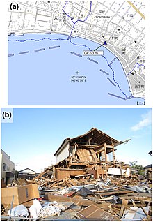
On March 11, 2011, the city was hit by the Tōhoku earthquake and the subsequent tsunami . The tsunami reached great heights locally in Asahi. Residential areas on the Pacific coast suffered severe damage in Asahi, with 14 people killed and 2 others missing. 318 residential buildings in Asahi were completely destroyed and 847 others were partially destroyed. In the district of Hiramatsu (平 松), which was densely built up with buildings, traces of water indicated a flood height of 6.3 m. In the Ashikawa district (足 川), a flood height of 5.1 m and a run-up height of 7.9 m were measured.
traffic
- Street:
- National Road 126
- Train:
Neighboring cities and communities
Town twinning
- Chino , Japan
- Nakagusuku , Japan
sons and daughters of the town
- Shōya Tomizawa (1990-2010), motorcycle racer
Web links
Individual evidence
- ↑ Yoshinobu Tsuji, Kenji Satake, Takeo Ishibe, Tomoya Harada, Akihito Nishiyama, Satoshi Kusumoto: Tsunami Heights along the Pacific Coast of Northern Honshu Recorded from the 2011 Tohoku . In: Pure and Applied Geophysics . tape 171 , no. 12 , 2014, p. 3183-3215 , doi : 10.1007 / s00024-014-0779-x . (Published online March 19, 2014). License: Creative Commons Attribution 4.0 International (CC BY 4.0). Here: p. 3194, Figure 13.
- ↑ a b c d Yoshinobu Tsuji, Kenji Satake, Takeo Ishibe, Tomoya Harada, Akihito Nishiyama, Satoshi Kusumoto: Tsunami Heights along the Pacific Coast of Northern Honshu Recorded from the 2011 Tohoku . In: Pure and Applied Geophysics . tape 171 , no. 12 , 2014, p. 3183-3215 , doi : 10.1007 / s00024-014-0779-x . (Published online March 19, 2014).
- ↑ a b 平 成 23 年 (2011 年) 東北 地方 太平洋 沖 地震 (東 日本 大 震災) に つ い て (第 157 報) ( Memento from March 18, 2018 on WebCite ) ( PDF ( Memento from March 18, 2018 on WebCite )), 総 務省 消防 庁 (Fire and Disaster Management Agency), 157th report, March 7, 2018.


