Higashi-Kanto Highway
| Higashi-Kanto Highway in Japan | ||||||||||||||||||||||||||||||||||||||||||||||||||||||||||||||||||||||||||||||||||||||||

|
||||||||||||||||||||||||||||||||||||||||||||||||||||||||||||||||||||||||||||||||||||||||
| map | ||||||||||||||||||||||||||||||||||||||||||||||||||||||||||||||||||||||||||||||||||||||||
| Basic data | ||||||||||||||||||||||||||||||||||||||||||||||||||||||||||||||||||||||||||||||||||||||||
| Operator: | NEXCO Higashi-Nihon | |||||||||||||||||||||||||||||||||||||||||||||||||||||||||||||||||||||||||||||||||||||||
| Start of the street: | Tokyo | |||||||||||||||||||||||||||||||||||||||||||||||||||||||||||||||||||||||||||||||||||||||
| End of street: | Kashima | |||||||||||||||||||||||||||||||||||||||||||||||||||||||||||||||||||||||||||||||||||||||
| Overall length: | 83 km | |||||||||||||||||||||||||||||||||||||||||||||||||||||||||||||||||||||||||||||||||||||||
| of which in operation: | 83 km | |||||||||||||||||||||||||||||||||||||||||||||||||||||||||||||||||||||||||||||||||||||||
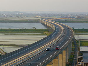
| Higashi-Kantō-Autobahn at Katori | ||||||||||||||||||||||||||||||||||||||||||||||||||||||||||||||||||||||||||||||||||||||||
|
Course of the road
|
||||||||||||||||||||||||||||||||||||||||||||||||||||||||||||||||||||||||||||||||||||||||
The Higashi-Kantō-Autobahn ( Japanese 東 関 東 自動 車道 , Higashi Kantō Jidōshadō ; dt. "East- Kantō -Autobahn") is a highway in Japan . It crosses the Chiba Prefecture in the east of the Japanese main island Honshū from Ichikawa to Katori and ends after a few kilometers in the Ibaraki Prefecture at the Itako Interchange ( Itako Intāchenji ) in Itako . The 74.5 km long highway is the ostjapanischen motorway operating company East Nippon Expressway Company (KK English. East Nippon Expressway Co., Ltd. , NEXCO ) operated and is known as "National mainline" ( Kokkandō , short for 国土開発幹線自動車道 , kokudo kaihatsu kansen jidōshadō ) classified.
Street description
The Higashi-Kanto Expressway begins at the level of the Edogawa River on the Bayshore Route from Yokohama and Tokyo and has 2 × 3 lanes here. It runs through the northern ports of Tokyo Bay in the city of Funabashi with 582,000 inhabitants. The freeway runs parallel to Keiyo Road, which runs a little north. One reaches the city of Chiba, one of the largest suburbs of Tokyo with approx. 930,000 inhabitants. The highway then turns northeast and crosses Keiyo Road at the Miyanogi intersection. Keiyo Road also goes from Tokyo to Chiba and then continues south. The Higashi-Kanto Expressway continues inland away from Chiba. The highway still has 2 × 3 lanes and leads through the typical Japanese suburbs with single-family houses. Then comes the city of Sakura, where there is a typical Dutch windmill. In the city of Narita there is a highway connection to Narita International Airport, the main international airport of Tokyo. After the airport motorway, the road narrows to 2 × 2 lanes. You are already 50 kilometers from downtown Tokyo. This area is hilly with some forests. Then the river Tone crosses the second river of Japan. Just before the city of Kashima, the highway ends as Itako.
history
The first section of the Higashi-Kantō-Autobahn between Miyano (in Chiba, Chiba) and Tomisato was opened in 1971 as the Shin-Kūkō-Autobahn ("New Airport Highway"). A year later it was extended to the Narita Interchange. After the completion of the New Tokyo International Airport in 1978, it was renamed the Higashi-Kanto Highway in 1979; only the connection from Narita Interchange to the airport, completed in 1978, is still called Shin-Kūkō-Autobahn. In 1982 the section from Ichikawa to Miyano was opened. In 1985 and 1986 extensions to Taiei (Narita, Chiba) and Sawara Katori (Katori, Chiba) followed in the east. The section to Itako was finally opened in 1987.
Opening dates of the motorway
| from | to | length | date |
|---|---|---|---|
| Miyanogi | Tomisato | 23 km | October 27, 1971 |
| Tomisato | Narita | 5 km | 08/19/1972 |
| Koya | Miyanogi | 17 km | 04/27/1982 |
| Narita | Taiei | 11 km | 02/27/1985 |
| Taiei | Sawara Katori | 9 km | 03/28/1986 |
| Sawara Katori | Itako | 9 km | 11/20/1987 |
| Ibaraki-minami | Ibaraki | 9 km | 03/06/2010 |
course
future
The section between Kashima and Ibaraki is to be opened by 2015 [obsolete] .
Traffic volume
The part at Funabashi is the busiest with 106,700 vehicles per day. There are still 10,600 vehicles per day by the end of the motorway at Itako.
Expansion of the roadways
| from | to | length | Lanes |
|---|---|---|---|
| Kōya | Narita | 45 km | 2 × 3 |
| Narita | Itako | 30 km | 2 × 2 |
| Ibaraki | Ibaraki | 9 km | 2 × 2 |
Web links
- Operating company Higashi-Nihon Kōsokudōro KK (Japanese)
- MLIT , Development Office Region Kantō: Driving time overview Higashi-Kantō-Autobahn (Japanese)
- Wegenwiki (Dutch)
