Kan'etsu Highway
| Kan'etsu Highway in Japan | |

|
|
| Basic data | |
| Operator: | NEXCO Higashi-Nihon |
| Overall length: | 246.3 km |
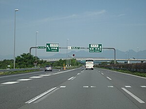
| Kan'etsu Highway at Takasaki | |
The Kan'etsu Highway ( Japanese 関 越 自動 車道 , Kan'etsu Jidōshadō ) is an important highway in Japan and crosses the Japanese main island of Honshū from Nerima to Nagaoka and meets the Hokuriku Highway here . Its course essentially follows that of National Road 17 .
The 246.3 km long highway is the ostjapanischen motorway operating company East Nippon Expressway Company (KK English. East Nippon Expressway Co., Ltd. , NEXCO ) operated and is known as "National mainline" ( Kokkandō , short for 国土開発幹線自動車道 , kokudo kaihatsu kansen jidōshadō ) classified.
history
The first section of the Kan'etsu highway between Nerima and Kawagoe was opened in 1971 as Tokyo-Kawagoe-dōrō .
Connection points ( interchange )
Nerima (1) - Tokorozawa (3) - Kawagoe (4) - Tsurugashima (5) - Higashimatsuyama (6) - Hanazono (7) - Honjō-Kodama (8) - Takasaki (10) - Maebashi (11) - Shibukawa-Ikaho (12) - Akagi (12-1) - Shōwa (12-2) - Numata (13) - Tsukiyono (14) - Minakami (15) - Yuzawa (16) - Shiozawa-Ishiuchi (16-1) - Muikamachi (17 ) - Koide (18) - Horinouchi (18-1) - Echigo-Kawaguchi (19) - Ojiya (20) - Nagaoka (21)
course
- Tokyo prefecture
- Saitama Prefecture
- Tokyo prefecture
- Saitama Prefecture
- Tokorozawa - Miyoshi - Fujimino - Kawagoe - Tsurugashima - Sakado - Higashimatsuyama - Namegawa - Ranzan - Ogawa - Yorii - Fukaya - Misato - Honjō - Kamisato
- Gunma Prefecture
- Niigata prefecture
Web links
- Operating company Higashi-Nihon Kōsokudōro KK (Japanese)
