Higashimatsuyama
| Higashimatsuyama-shi 東 松山 市 |
||
|---|---|---|
| Geographical location in Japan | ||
|
|
||
| Region : | Kanto | |
| Prefecture : | Saitama | |
| Coordinates : | 36 ° 3 ' N , 139 ° 24' E | |
| Basic data | ||
| Surface: | 65.33 km² | |
| Residents : | 92,302 (October 1, 2019) |
|
| Population density : | 1413 inhabitants per km² | |
| Community key : | 11212-7 | |
| Symbols | ||
| Flag / coat of arms: | ||
| Tree : | jaw | |
| Flower : | Shrub peony | |
| Song : | Higashimatsuyama-shi Uta | |
| town hall | ||
| Address : |
Higashimatsuyama City Hall 1 - 1 - 58 , Matsuba-chō Higashimatsuyama -shi Saitama 355-8601 |
|
| Website URL: | http://www.city.higashimatsuyama.lg.jp/ | |
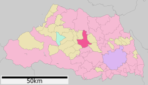
| Location of Higashimatsuyamas in Saitama Prefecture | ||
Higashimatsuyama ( Japanese 東 松山 市 , - shi ) is a city in the center of Saitama Prefecture . The city is famous for yakitori .
geography
Higashimatsuyama is north of Sakado and Kawagoe , south of Kumagaya and west of Kōnosu .
history
Higashimatsuyama was made Shi on September 30, 1954 .
economy
Bosch Japan has one of the Group's largest plants in the country in Higashimatsuyama.
Attractions
- “Takasaka Sculpture Promenade” ( 高 坂 彫刻 プ ロ ム ナ ー ド ): 32 sculptures by Takada Hiroatsu .
- Shōbō-ji , Buddhist temple
traffic
- Street:
- Kanetsu Highway , to Tokyo or Niigata
- National Road 254, to Tokyo
- Train:
- Tōbu Tōjō main line , after Ikebukuro or Yorii
Neighboring cities and communities
Town twinning
-
 Nijmegen , since 1996
Personalities
- Taishi Matsumoto (* 1998), football player
- Ryōma Watanabe (born 1996), football player
Web links
Commons : Higashimatsuyama - collection of images, videos and audio files
Individual evidence
- ↑ http://www.bosch.co.jp/en/japan/facilities/ Locations Bosch Japan


