Kawaguchi
| Kawaguchi-shi 川口 市 |
||
|---|---|---|
| Geographical location in Japan | ||
|
|
||
| Region : | Kanto | |
| Prefecture : | Saitama | |
| Coordinates : | 35 ° 48 ' N , 139 ° 43' E | |
| Basic data | ||
| Surface: | 55.75 km² | |
| Residents : | 592,373 (October 1, 2019) |
|
| Population density : | 10,626 inhabitants per km² | |
| Community key : | 11203-8 | |
| Symbols | ||
| Flag / coat of arms: | ||
| Tree : | Camellia sasanqua | |
| Flower : | Easter lily | |
| town hall | ||
| Address : |
Kawaguchi City Hall 2 - 1 - 1 , Aoki Kawaguchi -shi Saitama 332-8601 |
|
| Website URL: | http://www.city.kawaguchi.lg.jp | |
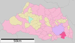
| Location of Kawaguchi's in Saitama Prefecture | ||
Kawaguchi ( Japanese 川口 市 , Kawaguchi-shi ) is a city in Saitama Prefecture on Honshū , the main island of Japan . It is located on the northern edge of Tokyo . On April 1, 1933, Kawaguchi became an independent city ( -shi ).
Mechanical engineering , the textile industry, glass and iron products and the electrotechnical industry are economically important .
geography
Kawaguchi is north of Tokyo , south of Saitama , west of Sōka and east of Toda and Warabi .
history
As an independent city, Kawaguchi (Kawaguchi-shi) was created in 1933 through the merger of the city of Kawaguchi (Kawaguchi-machi) with three other villages in the district of North Adachi ( Kita-Adachi-gun ) . In 1940, 1956 and 1962 other village communities were incorporated. On October 11, 2011, the independent cities of Kawaguchi and Hatogaya merged to form the new Kawaguchi. In 2018 it was named the “core city” .
traffic
Street
-
Higashi-Nihon Kōsokudōro (East Japanese Highways)
- Tōhoku Highway
- Tōkyō-Gaikan Highway (Outer Ring Tokyo)
- Tokyo city highway
- Ministry of Land and Transport
train
- JR Higashi-Nihon ("JR East Japan", Engl. JR East )
- Keihin-Tōhoku Line , Kawaguchi Station and Nishi-Kawaguchi Station to Yokohama and Saitama, respectively
- Musashino Line , Higashi-Kawaguchi Station to Funabashi or Kokubunji
-
Saitama Kōsoku Tetsudō (English Saitama Railway)
- Saitama-Kōsoku-Tetsudō Line
sons and daughters of the town
- Chara (singer) (* 1968)
- Kenta Hirose (* 1992), soccer player
- Kazuki Kaneshiro (* 1968), Japanese-Korean author
- Ruki Tobita (* 1999), Japanese snowboarder
Neighboring cities and communities
Web links
Individual evidence
- ↑ Kawaguchi City: 川口 市 の 概要 ・ 歴 史 , accessed October 17, 2018


