Wakō (Saitama)
| Wakō-shi 和 光 市 |
||
|---|---|---|
| Geographical location in Japan | ||
|
|
||
| Region : | Kanto | |
| Prefecture : | Saitama | |
| Coordinates : | 35 ° 47 ' N , 139 ° 36' E | |
| Basic data | ||
| Surface: | 11.04 km² | |
| Residents : | 83,895 (October 1, 2019) |
|
| Population density : | 7599 inhabitants per km² | |
| Community key : | 11229-1 | |
| Symbols | ||
| Flag / coat of arms: | ||
| Tree : | ginkgo | |
| Flower : | Rhododendron indicum | |
| town hall | ||
| Address : |
Wakō City Hall 1 - 5 , Hirosawa Wakō -shi Saitama 351-0192 |
|
| Website URL: | http://www.city.wako.saitama.jp | |
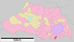
| Location of Wakos in Saitama Prefecture | ||
Wakō ( Japanese 和 光 市 , -shi ) is a city in Saitama Prefecture on Honshū , the main island of Japan .
geography
Wakō is east of Tokorozawa , south of Saitama and north of Tokyo .
history
The city of Wakō was founded on October 31, 1970 . Initially, Honda had its production facility there. The factory has since been relocated, but the Honda Research Institute is still located there. Wakō is also the headquarters of the world-renowned government research institute RIKEN . The population rose from 40,000 when it achieved city status to around 80,000 at present.
traffic
- Street:
- National Road 254, to Kawagoe
- Train:
Factories
Neighboring cities and communities
Web links
Commons : Wakō - collection of images, videos and audio files


