Saitama
| Saitama-shi さ い た ま 市 |
||
|---|---|---|
| Geographical location in Japan | ||
|
|
||
| Region : | Kanto | |
| Prefecture : | Saitama | |
| Coordinates : | 35 ° 52 ' N , 139 ° 39' E | |
| Basic data | ||
| Surface: | 217.49 km² | |
| Residents : | 1,307,931 (October 1, 2019) |
|
| Population density : | 6014 inhabitants per km² | |
| Community key : | 11100-7 | |
| Symbols | ||
| Flag / coat of arms: | ||
| Tree : | Japanese zelkove | |
| Flower : | Siebold's primrose | |
| Blooming tree: | cherry | |
| Song : | Kibō no machi (City of Hope) | |
| town hall | ||
| Address : |
Saitama City Hall 6 - 4 - 4 , Tokiwa Urawa-ku , Saitama -shi Saitama 330-9588 |
|
| Website URL: | http://www.city.saitama.jp/ | |
| Location Saitamas in Saitama Prefecture | ||
Saitama ( Japanese さ い た ま 市 , -shi ) is the youngest city in Japan with a population of 1,307,931 (October 1, 2019) covering an area of 217.49 square kilometers. It is located north of the Japanese capital Tokyo , in the south of the Saitama prefecture of the same name in the Kantō plain and is the seat of the prefecture administration.
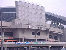
Saitama is part of the Tokyo metropolitan area and is only 15 minutes from Tokyo by Shinkansen . The largest centers of public life are concentrated around the railway stations Omiya (with 310,400 passengers per day the largest train station in the prefecture), Shintoshin (with the Saitama Super Arena ) and Urawa. Some games of the 2002 World Cup were played at Saitama Stadium , which is also home to the Urawa Reds first division team .
geography
Administrative division
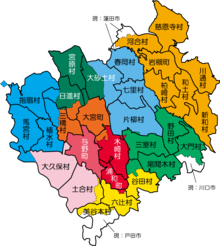
The city is divided into ten boroughs ( 区 - ku ), each of which has had an official color since April 2005:
| No. in card |
Code with check digit |
District name | Area (in km 2 ) (Oct. 1, 2018) 1 |
population | Population density (in Ew / km 2 ) |
Origin 4 (former city) |
||
|---|---|---|---|---|---|---|---|---|
| Rōmaji | Kanji | October 1, 2018 2 | Oct. 1, 2015 3 | |||||
| 1 | 11105-8 | Nishi-ku | 西区 | 8.39 | 100,765 | 98,762 | 11,771.39 | Ōmiya |
| 2 | 11110-4 | Kita-ku | 北区 | 49.17 | 110,771 | 109,801 | 2233.09 | Ōmiya |
| 3 | 11102-3 | Ōmiya-ku | 大 宮 区 | 16.86 | 145.122 | 143,446 | 8508.07 | Ōmiya |
| 4th | 11109-1 | Minuma-ku | 見 沼 区 | 26.44 | 122,311 | 116,522 | 4407.03 | Urawa |
| 5 | 11108-2 | Chūō-ku | 中央 区 | 13.82 | 188,462 | 180.152 | 13035.6 | Yono |
| 6th | 11104-0 | Sakura-ku | 桜 区 | 30.69 | 163,445 | 161.960 | 5277.29 | Urawa |
| 7th | 11101-5 | Urawa- ku | 浦 和 区 | 29.12 | 89,783 | 87,146 | 2992.65 | Urawa |
| 8th | 11103-1 | Minami-ku | 南 区 | 12.80 | 116.157 | 113,864 | 8895.63 | Ōmiya |
| 9 | 11106-6 | Midori-ku | 緑 区 | 18.64 | 98,334 | 97.910 | 5252.68 | Urawa |
| 10 | 11107-4 | Iwatsuki-ku | 岩 槻 区 | 11.51 | 160,457 | 154,416 | 13,415.81 | Iwatsuki |
| 11100-1 | Saitama-shi | さ い た ま 市 | 217.43 | 1,295,607 | 1,263,979 | 5813.27 | ||
1 Area data from 2018
2 Estimated population 2018
3 Results of the 2015 census
4 Origin of the city districts: Names of the former cities from which the city of Saitama was formed in 2001.
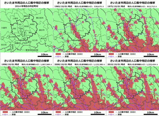
The administrative center with the town hall is in Urawa-ku. Otherwise, Saitama is very decentralized, as a cohesive urban carpet has neither an urban development center nor any other legible urban structure (its geographical center is roughly in Saitama-Shintoshin), and it flows seamlessly into the neighboring cities at its borders.
Neighboring cities and communities
The Arakawa flows through Saitama .
history
Most of what is now Saitama City was historically in Adachi County (later North Adachi ) in Musashi Province , only Iwatsuki, which was incorporated in 2005, was in Saitama County (later South Saitama ). In the Edo period, large parts of the Musashi province around the seat of government Edo and also the district of Adachi Hatamoto or Shogunat land ( bakuryō ) , so not part of a principality (- han ) . In the northeast, the Ōoka ruled from Iwatsuki Castle over the Principality of Iwatsuki , which at the end of the Edo period extended across parts of Saitama County, but also comprised possessions in other provinces, especially Kazusa .


In the Meiji period, North Adachi and South Saitama counties became part of Saitama Prefecture (-ken) , the administrative seat of which was established in what would later become the city of Urawa. In the 20th century, the area was gradually consolidated into four independent cities (-shi) : Urawa, the prefecture capital of Saitama and former county seat of northern Adachi, was only the fourth city in Saitama (after Kawagoe, Kumagaya and Kawaguchi) in 1934 absorbed several neighboring parishes in the 1940s and 50s. Ōmiya merged with four neighboring communities in 1940, became a district at the same time and expanded to include other surrounding communities in 1956, Iwatsuki, once the seat of the district administration of South Saitama, became a district in 1954 and Yono - largely without any change of area since 1889 - finally in 1958.
The independent city (-shi) Saitama was created by decree on May 1, 2001 from the cities of Urawa , Ōmiya and Yono . In 2003 it was divided into cities and districts ( - ku ) by ordinance . On April 1, 2005, the neighboring city of Iwatsuki was also incorporated. This makes Saitama the tenth largest city in Japan today.
With the unification of the cities of Urawa, Omiya and Yono, the newly created prefecture capital should also be given a new name. In a public survey, the prefectural name Saitama ( 埼 玉 ), written in the usual Chinese characters , prevailed. Even so, the officials opted for the hiragana syllabary version ( さ い た mit) with an identical pronunciation, which came in second in the poll. Third place went to the name Omiya, and fourth place Saitama ( 彩 玉 ), written with an alternative Kanji for sai ( 彩 ), which means colorful . Saitama is the only prefecture capital that spells only in hiragana.
The name of Saitama Prefecture is derived from the name of Saitama County ( 埼 玉 郡 , Saitama-gun , historically also Sakitama-gun ) in the east, whose name is from Sakitama (with the Sakitama Kofung group ) in the northern part of Saitama County, today part of the city of Gyōda . Sai ( 埼 ) is a rarer version of the character 崎 ( sai ) and means mountain foothills , tama ( 玉 ) stands for ball or sphere .
Saitama Shintoshin
As early as 1986, considerations began to build a new, common center for the new prefecture capital Saitama, Saitama-Shintoshin ( さ い た ま 新都 心 ), the new city center Saitama . From 1991 until the opening in 2000 on an area of more than 47 hectares in the south of Ōmiya, on the border to Urawa and Yono, a unique and striking urban ensemble of four office and hotel high-rises, a telecommunications tower, a new S-Bahn station, a shopping center and the Saitama Super Arena event hall around the Keyaki-Hiroba public square. Saitama-Shintoshin is one of the most important Japanese inner-city projects, comparable to Tokyo's high-rise district Nishi- Shinjuku and Minato Mirai 21 in Yokohama .
A total of around 1,800,000 square meters were built. The NTT DoCoMo Saitama Building (NTT ド コ モ 埼 玉 ビ ル ) telecommunications tower is the tallest structure in Saitama Prefecture at 218.50 meters, while the Land Axis Tower ( ラ ン ド ・ ア ク シ ス ・ タ ワ ー ) is the tallest building at 168.30 meters. The neighboring Saitama Government Tower 1 (153.90 meters), Saitama Government Tower 2 (138.70 meters) and Saitama-Shintoshin MPT Building (129.80 meters) follow in positions two, three and four of the tallest buildings. The planned construction of the more than 300 meter high Saitama Tower (and thus theoretically the tallest building in Japan) has not yet been realized.
Population development
Saitama is currently the tenth largest city in Japan with 1,193,926 inhabitants, 599,037 men and 594,889 women live in a total of 494,112 households. The average age is 39.8 years (38.9 for men and 40.7 for women).
politics
Mayor of Saitama (Saitama shichō) has been Hayato Shimizu since 2009 . It was on May 21, 2017 63.5% of the vote against the former Liberal Democrat lower house deputies Fukuyo Nakamori re-elected and the Communists Hideo Maejima for a third term.
The city parliament of Saitama (Saitama shigikai) regularly has 60 members, who were elected in ten constituencies that are congruent with the city districts in the unified elections in April 2019 . The Liberal Democratic Party remained the strongest party with 23 seats. However, since a split in 2017, their MPs have been split between two parliamentary groups.
The city of Saitama elects 14 members to the 93-member prefectural parliament of Saitama (Saitama kengikai) , the districts also serve as constituencies: six one-mandate and four two-mandate constituencies. The prefectural parliamentary elections also take place in a single election cycle.
For the lower house of the national parliament , since a reorganization of the constituencies in 2002, the city extends into constituencies 1, 5 and 15 (also includes the southern neighboring cities of Warabi and Toda as well as part of Kawaguchi since 2017) of Saitama prefecture, which after the 2017 election will be represented unchanged by the Liberal Democrats Hideki Murai and Ryōsei Tanaka and the founder of the Constitutional Democrats Yukio Edano .
Town twinning
Saitama has international partnerships with the following cities:
-
 Toluca , Mexico , since 1979 with Urawa
 -
 Zhengzhou , China , with Urawa since 1981
 -
 Hamilton , New Zealand , with Urawa since 1984
 -
 Richmond (Virginia) , USA , with Urawa since 1994
 -
 Nanaimo , Canada , with Iwatsuki since 1996
 -
 Pittsburgh , USA, with Ōmiya since 1998
And partnerships with the following locations in Japan:
-
 Minami-Aizu (originated from Nangō, partnership since 1975 with Urawa at the time, and Tateiwa, since 1982 with Ōmiya).
 -
 Minamibōsō , since 1981 with Iwatsuki
 -
 Minami-Uonuma , with Yono since 1988
 -
 Minakami , since 2004.
 -
 Kamogawa , since 2004.
Culture and sights
Sports
Saitama is home to two football clubs that play in the professional league J. League : The current champion Urawa Reds plays in the Saitama Stadium , which was built for the 2002 World Cup , and in the smaller Urawa Komaba Stadium , the local rival Ōmiya Ardija in the Omiya Park Stadium .
The second team of the Chiba Lotte Marines baseball team has been based in the Lotte Urawa baseball stadium ( Lotte Urawa Kyūjō ) since 1989 .
Universities
Attractions
- Iwatsuki Castle
- Hikawa shrine
- Jion-ji
- Ōmiya bonsai village
- Tajimagahara primrose habitat, special natural monument of Japan
Infrastructure
traffic
train
- JR Tōhoku Shinkansen , Omiya Station , to Tōkyō or Hachinohe
- JR Jōetsu Shinkansen , Omiya Station, to Tōkyō or Niigata
- JR Nagano Shinkansen , Omiya Station, to Tōkyō or Nagano
- JR Takasaki Line , Urawa , Saitama-Shintoshin , Omiya, and Miyahara stations , to Ueno (Tokyo) or Takasaki
- JR Keihin-Tōhoku Line , Minami-Urawa , Urawa, Kita-Urawa , Saitama-Shintoshin and Omiya stations to Yokohama
- JR Saikyō Line , Musashi-Urawa , Naka-Urawa , Minami-Yono , Yono-Honmachi , Kita-Yono and Omiya stations, to Shinjuku and Odaiba
- JR Kawagoe Line , Sashiogi , Nisshin and Omiya stations, to Kawagoe
- JR Utsunomiya Line , Urawa , Saitama-Shintoshin , Omiya, Toro , Higashi-Omiya stations to Utsunomiya and Aomori
- JR Musashino Line , Nishi-Urawa , Musashi-Urawa , Minami-Urawa and Higashi-Urawa stations , to Funabashi and Fuchu
- Tōbu Noda line to Funabashi
Subway
- Saitama Kosoku Railway
Street
- Tōhoku Highway : to Aomori
- National Road 17 : to Tokyo or Niigata
- National Road 16 : to Yokosuka , Yokohama , Hachiōji or Chiba
- National Road 122: to Tokyo or Nikko
- Nakasendo
- Sangyoh Dohro
Personalities
- Toshirō Mutō (* 1943), Deputy Governor of the Bank of Japan
- Mutsumi Aoki (* 1959), visual artist
- Hiroaki Mizutani (* 1963), jazz musician
- Kōichi Wakata (* 1963), spaceman
- Asa Higuchi (* 1970), manga artist
- Takashi Sorimachi (* 1973), television actor and singer
- Yūji Ide (* 1975), racing driver
- Daijirō Katō (1976-2003), motorcycle racer
- Eiji Kawashima (* 1983), football player
- Yoshitaka Ōhashi (born 1983), football player
- Kōya Saitō (* 1986), football player
- Satomi Akesaka (* 1988), seiyū, actress and musician
- Kensuke Satō (* 1989), football player
- Takeru Satoh (born 1989), film actor
- Masashi Wakasa (* 1989), soccer player
- Kōsuke Taketomi (* 1990), football player
- Yūta Fujii (* 1991), soccer player
- Tetsuro Inoue (* 1991), football player
- Toshiki Ishikawa (* 1991), football player
- Shunsuke Kikuchi (born 1991), soccer player
- Yūkō Takase (* 1991), football player
- Yukiya Sugita (* 1993), soccer player
- Yūsuke Kobayashi (* 1994), football player
- Kengo Nagai (* 1994), soccer player
- Hiroto Nakagawa (* 1994), football player
- Mayu Watanabe (* 1994), singer, actress
- Rikuto Hirose (* 1995), football player
- Kazaki Nakagawa (born 1995), football player
- Keisuke Ōyama (born 1995), football player
- Shōta Saitō (* 1996), football player
- Masato Tokida (born 1997), football player
- Yūki Hashioka (* 1999), track and field athlete
See also
- Urawa (former capital of the prefecture, now a district of Saitama)
- Saitama Super Arena
Individual evidence
- ↑ Kokudo Chiriin (GSI - Geospatial Information Authority of Japan), 平 成 30 年 全国 都 道 府 県 市区 町 村 別 面積 調 (Nationwide survey of all prefectures and municipalities 2018) , p. 34: 11 Saitama-ken (Japanese), accessed on 17 March 2019.
- ↑ 簡 単 検 索 ・ 詳細 検 索 ・ 検 索 サ ン プ ル , accessed March 17, 2019. (Japanese)
- ↑ e-stat (English), accessed on March 17, 2019.
- ↑ Saitama shigikai: fractions (Japanese), accessed on May 23, 2019
- ^ Shimizu cruises to third term in Saitama mayoral race. In: The Japan Times . May 22, 2017, accessed March 17, 2018 .
- ↑ 2017 年 さ い た ま 市長 選 . In: NHK perpendicular web. May 21, 2017. Retrieved March 17, 2018 (Japanese).
- ↑ 統一 地方 選 2019 さ い た ま 市 議 選 各 党 議席 . In: NHK Senkyo Web. April 8, 2019. Retrieved May 23, 2019 (Japanese).
- ↑ さ い た ま 市 議会 で 自 民 が 分裂 議会 運 営 巡 り 溝 、 民進 が 最大 会 派 に . In: nikkei.com . March 11, 2017. Retrieved March 17, 2018 (Japanese).
- ↑ Saitama kengikai: constituencies


