Kazo
| Kazo-shi 加 須 市 |
||
|---|---|---|
| Geographical location in Japan | ||
|
|
||
| Region : | Kanto | |
| Prefecture : | Saitama | |
| Coordinates : | 36 ° 8 ′ N , 139 ° 36 ′ E | |
| Basic data | ||
| Surface: | 133.47 km² | |
| Residents : | 110,921 (October 1, 2019) |
|
| Population density : | 831 inhabitants per km² | |
| Community key : | 11210-1 | |
| Symbols | ||
| Flag / coat of arms: | ||
| Tree : | ginkgo | |
| Flower : | azalea | |
| town hall | ||
| Address : |
Kazo City Hall 2 - 1 - 1 , Mitsumata Kazo shi Saitama 347-8501 |
|
| Website URL: | http://www.city.kazo.lg.jp | |
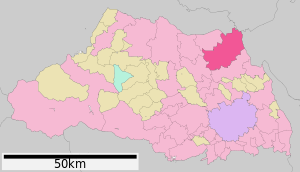
| Location Kazos in Saitama Prefecture | ||
Kazo ( Japanese 加 須 市 , - shi ) is a city in the north of Saitama Prefecture . Kazo is where most of the famous carp flags are made and the city is considered their home. Kazo is also famous for its udon .
geography
The Tone River flows to the north .
history
Kazo received town charter on May 3, 1954. The asteroid (11504) Kazo , discovered on January 21, 1990 , was named after the city in May 2001.
Events
- February 3 : As part of the Setsubun festival , the traditional spreading of soybeans takes place in Fudooka .
- May 3: The Jumbo Koinobori , the largest carp flag in the world, is hoisted on the Tone River .
- fourth Sunday of July: summer festival
- third Sunday of October: parade of the city's primary schools
traffic
- Street:
- Tōhoku Highway
- National road 122, to Tōkyō or Nikkō
- National Road 125, to Kumagaya or Oyama
- Train:
- Tōbu Nikkō Line (branch of the Tōbu Isesaki Line ), to Asakusa or Nikkō
Neighboring cities and communities
- Saitama Prefecture
- Gunma Prefecture
- Tochigi prefecture
- Ibaraki prefecture
Web links
Commons : Kazo - collection of images, videos and audio files


