Manzanillo (Mexico)
| Manzanillo | ||
|---|---|---|
|
Coordinates: 19 ° 3 ′ N , 104 ° 19 ′ W Manzanillo on the map of Colima
|
||
| Basic data | ||
| Country | Mexico | |
| State | Colima | |
| Municipio | Manzanillo | |
| City foundation | 1527 | |
| Residents | 130,035 (2010) | |
| City insignia | ||
| Detailed data | ||
| height | 4 m | |
| Post Code | 28200 | |
| prefix | 314 | |
| City Presidency | Virgilio Mendoza Amezcua | |
| Website | ||
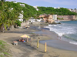
| Playa Santiago in Manzanillo | ||
| Manzanillo | ||||||||||||||||||||||||||||||||||||||||||||||||
|---|---|---|---|---|---|---|---|---|---|---|---|---|---|---|---|---|---|---|---|---|---|---|---|---|---|---|---|---|---|---|---|---|---|---|---|---|---|---|---|---|---|---|---|---|---|---|---|---|
| Climate diagram | ||||||||||||||||||||||||||||||||||||||||||||||||
| ||||||||||||||||||||||||||||||||||||||||||||||||
Manzanillo is a port city in the Mexican state of Colima . It has 130,035 inhabitants (2010) and is the administrative seat of the Municipio Manzanillo .
Located on the Pacific Ocean , Manzanillo is home to one of the largest ports in Mexico. In 2004 the city overtook Veracruz as the largest port in Mexico in terms of the volume of unloaded cargo. In the port of Manzanillo there is a large landing point for tuna fishing vessels.
tourism
The airport offers direct connections to the USA and Canada, which is why there are many tourists from these areas seasonally. Most of the hotels are located on the long sandy beach in the north, but the beach itself is not ideal for swimming because of the surf there. The center of the city is in the south. There is the "Blue Fish" statue as well as many shops and cafes.
Manzanillo has an extensive beach and is a fishing center with an abundance of sailfish . There is a fanfish fishing competition every year.
traffic
The regional airport of Manzanillo is in the north and is about 20 minutes by car from Manzanillo. The airport has regular direct connections to the USA, Canada and Mexico City as well as irregular domestic connections. The most important airlines in Manzanillo are Alaska Airlines, Aeromar, Aeromexico, Inter Jet, Spirit Airlines and Jet Blue Airlines.
The seaport is one of the most important in Mexico. It is mainly called by container ships, but also by bulk carriers, fishermen and tankers. The market leaders in container traffic are Hamburg-Süd, Maersk Line, CCNI and MSC. Manzanillo is also a destination for cruise ships, which frequently depart from Los Angeles and San Francisco and call at several ports on Mexico's east coast.
Manzanillo has an extensive bus network, and there are taxis, which are also not very expensive. In general, the road is the only mode of transport within the region. There are larger roads to Colima, Melaque in the north and south towards Lazaro Cardenas / Acapulco.


