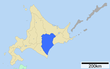
Tokachi Sub-Prefecture
Tokachi ( Japanese 十勝 総 合 振興 局 , Tokachi-sōgō-shinkō-kyoku ) is a sub- prefecture of Hokkaidō Prefecture . It has an area of 10,830.99 km² and a population of 358,653 (as of September 30, 2006).
history
In November 1897, the Kasai sub-prefecture ( 河西 支 庁 , Kasai-shichō ) was established. In August 1932, the name was changed to Tokachi Sub-prefecture ( 十勝 支 庁 , Tokachi-shichō ). Tokachi was the name of a province of the same name that was here from 1869 to 1882 before the prefectures were established.
On October 20, 1948, Ashoro County was slammed from Kushiro Sub-prefecture to Tokachi Sub-prefecture.
When Hokkaidō was reorganized on April 1, 2010, it was renamed Tokachi-sōgō-shinkō-kyoku .
Administrative division
Big cities ( 市 , shi )
- Seat of the sub-prefecture administration: Obihiro
Counties ( 郡 , gun )
List of counties in the Tokachi sub-prefecture, as well as their cities ( 町 , chō ) and villages ( 村 , mura ).
Reorganizations
- On February 6, 2006, Chūrui Village in Hiroo County was incorporated into Makubetsu City in Nakagawa County.
traffic
Tokachi-Obihiro Airport is located in Obihiro .
Web links
- Official Website of the Sub-Prefecture (Japanese)


