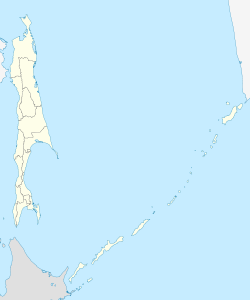
Cholmsk
| city
Kholmsk
Холмск
|
||||||||||||||||||||||||||||||||||||||||||
|
||||||||||||||||||||||||||||||||||||||||||
|
||||||||||||||||||||||||||||||||||||||||||
| List of cities in Russia | ||||||||||||||||||||||||||||||||||||||||||
Cholmsk ( Russian Холмск ) is a city in Sakhalin Oblast ( Russia ) with 30,937 inhabitants (as of October 14, 2010).
geography
The city is located on the west coast of the southern part of the Sakhalin Island , about 80 km west of the Oblast capital Yuzhno-Sakhalinsk , on the Nevelskoi Bay of the Sea of Japan .
The city of Cholmsk is administratively directly subordinate to the Oblast and at the same time the administrative center of the raion of the same name .
history
The place was founded by the landing of ten soldiers on May 21, 1870 as a Russian military post. The place name Mauka was adopted from the Ainu language. From 1905 to 1945 he belonged to the Treaty of Portsmouth , which ended the Russo-Japanese War 1904–1905, as Maoka ( Japanese 真 岡 町 , - chō , literally: "real / true hill") to Japan. As a result of the Second World War , the city came back to the Soviet Union and received city rights in 1946 under its current name (from Russian cholm for hill, in reference to the terraced arrangement of the place around the harbor bay).
Population development
| year | Residents |
|---|---|
| 1941 | 19.193 |
| 1959 | 31,541 |
| 1970 | 37,412 |
| 1979 | 45.158 |
| 1989 | 51,381 |
| 2002 | 35.141 |
| 2010 | 30,937 |
Note: census data
Economy and Infrastructure
The city is characterized by shipping and fishing. The port serves as a sea, ferry and fishing port and is the base of operations for the fishing fleet of Sachmore products and the Sakhalin shipping company (Sachalinskoje morskoje parochodstwo). There is also a paper mill as well as construction and food industries.
Cholmsk is the terminus of the railway ferry connection to Vanino on the Russian mainland ( Khabarovsk region ). The city is located on the narrow-gauge railway line ( cape gauge 1067 mm) running along the west coast of the island, Ilyinsk - Shakhta-Sakhalinskaya . The direct rail connection to the Oblast capital Yuzhno-Sakhalinsk was largely shut down due to the poor condition of the line in 1994, it is only in operation from Kholmsk to the Nikolaichuk stop . Kholmsk has an airport.
sons and daughters of the town
- Ri Kaisei (* 1935), Japanese writer of Korean descent
- Tadashi Nakamura (* 1942), Japanese martial arts expert
- Igor Jurjewitsch Nikolajew (* 1960), singer and songwriter
- Maxim Scheiko (* 1988), weightlifter
Individual evidence
- ↑ a b Itogi Vserossijskoj perepisi naselenija 2010 goda. Tom 1. Čislennostʹ i razmeščenie naselenija (Results of the All-Russian Census 2010. Volume 1. Number and distribution of the population). Tables 5 , pp. 12-209; 11 , pp. 312–979 (download from the website of the Federal Service for State Statistics of the Russian Federation)
Web links
- City administration website (Russian)
- City Portal (Russian)
- Cholmsk on mojgorod.ru (Russian)


