Smirnych
| Urban-type settlement
Smirnych
Смирных
|
||||||||||||||||||||||||||||||||||
|
||||||||||||||||||||||||||||||||||
|
||||||||||||||||||||||||||||||||||
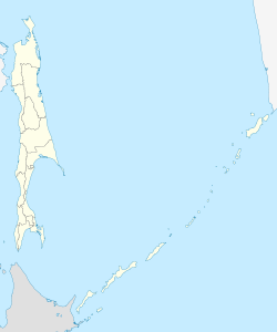
Smirnych ( Russian Смирных ) is an urban-type settlement in Sakhalin Oblast ( Russia ) with 7,399 inhabitants (as of October 14, 2010).
geography
The settlement is located in the central part of Sakhalin Island , in the wide lowland formed by the Poronai River between the western and eastern parts of the Sakhalin Mountains. It is about 70 kilometers from the coast of the Sea of Okhotsk , the Terpenije Bay near Poronaisk . The Orlowka flows through Smirnych and flows ten kilometers east into the Poronai.
Smirnych has been the administrative center of the Smirnych Rajon of the same name on January 16, 1965. The place is a good 350 kilometers (as the crow flies) north of the Oblast capital Yuzhno-Sakhalinsk .
history
During the affiliation of the southern part of the island of Sakhalin to Japan from 1905, the district Keton ( Japanese 気 屯 ) of the city of Shikuka (today: Poronaisk) existed in place of today's Smirnych . As a result of the Second World War , the southern part of Sakhalin also came to the Soviet Union, and the place was given its current name in 1947 in honor of the battalion commander of the Red Army, Captain Leonid Smirnych, who was killed in the fighting for the area in 1945 (a village in the Rajon was named after Sergeant Anton Bujukly, who also fell there ; both were also named Heroes of the Soviet Union ).
In 1966 the place was given the status of an urban-type settlement, apparently in connection with the creation of an air force base immediately east of the place at that time. From this base, MiG-23 interceptors took off on September 1, 1983 , and were involved in the action that resulted in the downing of a South Korean Boeing 747 .
Population development
| year | Residents |
|---|---|
| 1959 | 5758 |
| 1970 | 5964 |
| 1979 | 7344 |
| 1989 | 9693 |
| 2002 | 7561 |
| 2010 | 7399 |
Note: census data
Economy and Infrastructure
The settlement is located on the main line of the narrow-gauge railway network ( cape gauge 1067 mm) of the Sakhalin Island leading to Nogliki (route kilometers 411 from Korsakow via Yuzhno-Sakhalinsk; station name Smirnych-Sakhalinsky ). Smirnych was reached during the construction of the northbound route towards the end of the 1940s.
The regional road R487 runs through the village from Yuzhno-Sakhalinsk via Poronaisk to Alexandrowsk-Sakhalinsky , from which the R491 branches off to Boschnjakowo on the west coast of the island.
Individual evidence
- ↑ a b Itogi Vserossijskoj perepisi naselenija 2010 goda. Tom 1. Čislennostʹ i razmeščenie naselenija (Results of the All-Russian Census 2010. Volume 1. Number and distribution of the population). Tables 5 , pp. 12-209; 11 , pp. 312–979 (download from the website of the Federal Service for State Statistics of the Russian Federation)
Web links
- Smirnych on the Sakhalin Oblast Administration website (in Russian)


