Severo-Kurilsk
| city
Severo-Kurilsk
Северо-Курильск
|
||||||||||||||||||||||||||||||||||||
|
||||||||||||||||||||||||||||||||||||
|
||||||||||||||||||||||||||||||||||||
| List of cities in Russia | ||||||||||||||||||||||||||||||||||||
Severo-Kurilsk ( Russian Северо-Курильск ) is a small town on the Kuril Islands in Sakhalin Oblast ( Russia ) with 2536 inhabitants (as of October 14, 2010).
geography
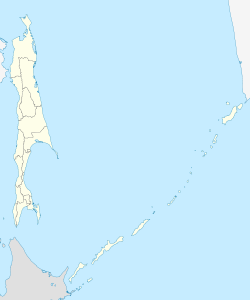
The city is located on the northeast coast of the second largest Kuril island, Paramushir , on the 3 to 4 km wide strait of the Second Kuril Road opposite the island of Shumschu , about 1065 km northeast of the Oblast capital Yuzhno-Sakhalinsk and 300 km southwest of Petropavlovsk-Kamchatsky . 7 km west of the city is the 1156 m high volcano Ebeko, which was last active at the end of March 2007 .
The city of Severo-Kurilsk is the administrative center of the raion of the same name .
history
Together with all Kuril Islands, the place belonged to Japan as Kashiwabara ( Japanese 柏 原 ) since 1875 . During the Second World War , Japanese troops surrendered on Paramushir on August 19, 1945. As a result of the war, the Kuril part of the Soviet Union and the city were renamed Severo-Kurilsk, which means North Kuril Islands (city) in 1946 .
On November 5, 1952 (local time), the city was practically completely destroyed by a tsunami . 2336 of the approximately 6000 inhabitants died. The tsunami caused by a seaquake 130 km off the coast of Kamchatka hit the city in three waves early in the morning. The residents, who were able to get to safety before the first wave and then returned to their homes, were then surprised by the second, largest wave. There was also destruction in other places in Kamchatka and the Kuril Islands.
The city was soon rebuilt at a slightly higher location. The old population was already exceeded after a few years, but then fell considerably when the fishing industry was relocated to other, larger centers in the region, especially with the economic crisis in Russia in the 1990s.
Population development
| year | Residents |
|---|---|
| 1959 | 7733 |
| 1970 | 3566 |
| 1979 | 4045 |
| 1989 | 5180 |
| 2002 | 2592 |
| 2010 | 2536 |
Note: census data
Culture, education and sights
In Severo-Kurilsk there is a small museum of local history with exhibits on the indigenous people of the islands (the Ainu ) as well as on the history, especially the time of belonging to Japan, the events of World War II and the tsunami of 1952.
There are many remains of Japanese defenses in the area.
economy
Fishing is practically the only industry in the city. There is a fishing port.
swell
- ↑ a b Itogi Vserossijskoj perepisi naselenija 2010 goda. Tom 1. Čislennostʹ i razmeščenie naselenija (Results of the All-Russian Census 2010. Volume 1. Number and distribution of the population). Tables 5 , pp. 12-209; 11 , pp. 312–979 (download from the website of the Federal Service for State Statistics of the Russian Federation)
- ↑ Sakhalin Meteorological Service (Russian)
- ↑ The tsunami of 1952 ( memento of the original of March 12, 2007 in the Internet Archive ) Info: The archive link was automatically inserted and not yet checked. Please check the original and archive link according to the instructions and then remove this notice. on the website of the scientific institutions Sakhalin (Russian)
- ↑ Website of the local history museum at museum.ru (Russian)
Web links
- Severo-Kurilsk on sakhalin.info (Russian)
- Severo-Kurilsk on mojgorod.ru (Russian)


