Paramushir
| Paramushir | ||
|---|---|---|
| Paramushir ( Landsat 7 recording) | ||
| Waters | Pacific Ocean | |
| Archipelago | Kuril Islands | |
| Geographical location | 50 ° 20 ′ N , 155 ° 45 ′ E | |
|
|
||
| surface | 2 053 km² | |
| Highest elevation |
Tschikurachki 1816 m |
|
| main place | Severo-Kurilsk | |
| Port of Severo-Kurilsk with Second Kuril Road , opposite Shumshu | ||
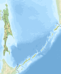
Paramushir ( Russian Парамушир , Japanese 幌 筵 島 , Paramushiru -tō , from the Ainu word for wide island ) is an island belonging to Russia in the northern Kuril group .
geography
The area of the island is 2053 km² . This makes Paramushir the largest island in the northern Kuril Islands and after Iturup the second largest island in the Kuril Islands. They are over 100 km long and 20 to 30 km wide.
Paramushir is separated from Shumshu Island in the northeast by the Second Kuril Strait (minimum width 2 km) , in the northwest by the Alaid Strait from Atlasov Island (with the Alaid volcano , 20 km), in the southwest by the Luzhin or Third Kuril Road from Anziferow Island (15 km) and to the south through the Fourth Kurile Road from Onekotan (55 km).
The backbone of the island make the Vernadsky ridge ( хребет Вернадского / Chrebet Wernadskowo; named after Vladimir Vernadsky ) in the northeast part and the Karpinski comb ( хребет Карпинского / Chrebet Karpinskogo, after the geologist Alexander Karpinski ) in the southwest, both of volcanic origin.
Five of the volcanoes that formed the island are active or potentially active. From north to south these are the Ebeko ( 1156 m ) in the Vernadsky ridge near Severo-Kurilsk, the Tschikurachki ( 1816 m , highest point on the island) and its secondary cone Tatarinow ( 1530 m ) at the northern end of the Karpinsky chain, the foot ( 1772 m ) isolated on a peninsula jutting out into the Sea of Okhotsk on the west coast , as well as the Karpinski ( 1345 m ) at the southern end of the Karpinski ridge.
A multitude of small islands, rocks and reefs protrude from the sea around the island. The island of Togari (also Hanimushir ) reaches a height of 47 meters.
Administratively, Paramushir belongs to the Severo-Kurilsk Raion ( Northern Kuril Islands ) of Sakhalin Oblast , with the city of Severo-Kurilsk as the administrative center, which is located near the northeast coast of the island and is the only permanently inhabited place on the island today. The previously existing settlements Anziferowa ( Анциферова ) Vasilyevo ( Васильево ) Galkino ( Галкино ) Kamenistý ( Каменистый ) Kitowy ( Китовый ) Majorowo ( Майорово ) Okeanskoje ( Океанское ) Pribreschny ( Прибрежный ) and Schelechowo ( Шелехово ) were either destroyed by a devastating tsunami on November 5, 1952 or later abandoned by its residents.
Flora and fauna
The slopes of the island up to a height of about 600 meters of dwarf pine - and alder wood knee overgrown, which is rich in berries ( cowberry , bilberry , arctic raspberries , crowberry ) and fungi is. The bank terraces and river valleys are covered by meadows.
Around 100 brown bears live on Paramushir, as well as red foxes , mountain hares and ermines , and sea otters on the coast .
In the largest river on the island, the 20 km long Tucharka (also Todoroki ), which flows east of the Karpinski ridge in a southerly direction, there are spawning grounds for pink salmon , sockeye salmon and silver salmon .
history
Together with the other Kuril Islands, Paramushir, previously inhabited only by Ainu, belonged to Japan since 1875 ( Treaty of Saint Petersburg ) . During the period of affiliation with Japan, the present-day Severero-Kurilsk city emerged and the economy began to develop, especially fishing on an industrial scale. But it arose z. B. also an iodine factory .
Expanded early on to become the northernmost Japanese military base after Shumushu, units of the 7th Division of the Japanese Army were stationed here in 1940 and their positions were subsequently heavily fortified. During the Second World War , the island was sporadically attacked by USAAF and US Navy from the Aleutians from 1943 until the end of the war . On April 12, 1945, it was the main base of the newly formed 91st Division to defend the Eastern Kuril Islands. After the Soviet declaration of war on August 8, 1945, the Red Army began the invasion of Paramushir. After fierce fighting, which also extended to the neighboring island of Shumshu and in which thousands of soldiers died on both sides, the Japanese troops surrendered on August 23. After the end of the war, the Soviet Union declared all Kuril Islands, including Paramushir, to be its national territory, which Japan recognized in the Treaty of San Francisco in 1951 (except for the South Kuril Islands, see Kuril conflict ).
On November 5, 1952, Paramushir was the center of a tsunami-affected area. Over a third of the island's population of over 6,000 was killed and practically all places were destroyed.
Individual evidence
- ↑ 北方 領土 の 位置 と 面積 ( Eng . "Location and area of the Northern Territories"). (No longer available online.) 北方 領土 問題 対 策 協会 ("Society for Actions on the Question of the Northern Territories"), self-governing body of the Cabinet Office , archived from the original on February 23, 2009 ; Retrieved July 3, 2009 (Japanese). Info: The archive link was inserted automatically and has not yet been checked. Please check the original and archive link according to the instructions and then remove this notice.


