
Schikotan
| Schikotan | ||
|---|---|---|
 |
||
| Waters | Pacific Ocean | |
| Archipelago | Kuril Islands | |
| Geographical location | 43 ° 48 ′ N , 146 ° 45 ′ E | |
|
||
| surface | 247.65 km² | |
| Highest elevation | Schikotan 405 m |
|
| Residents | 2820 (2010) 11 inhabitants / km² |
|
| main place | Malokurilskoye | |
 |
||

Schikotan ( Russian Шикотан , Japanese 色 丹 島 , Shikotan-tō , English Shikotan ) is one of the larger islands of the Kuril archipelago. It belongs to the Russian Sakhalin Oblast , but as the Habomai Islands Islands of Japan as part of the sub-prefecture Nemuro in the prefecture of Hokkaido claimed.
The name "Schikotan" comes from the Ainu language and is probably derived from si-kotan for "large village, large villages".
geography
The area of the island is 247.65 km². The island is formed by volcanic rocks and sandstone from the Upper Cretaceous and the Cenozoic . In contrast to many other Kuril Islands, there are no active volcanoes . Two extinct volcanoes are the Tomari (height 358 m ) and the Notoro ( 356 m ) in the southern part of the island, the highest point is the mountain Schikotan ( 405 m ) not far from the northern tip. The vegetation consists mainly of Sachalin firs , larches , deciduous forest , bamboo than undergrowth and Juniper -Buschland.
Today there are two villages on the island: Malokurilskoje (formerly Shikotan ) not far from the northern tip of the island with 1873 inhabitants and Krabosawodskoje (formerly Anama ) on the central part of the northwest coast with 947 inhabitants (as of 2010). The places belong to the urban district of Yuzhno-Kurilsk with the administrative center in the urban-type settlement Yuzhno-Kurilsk on the northwestern neighboring island of Kunashir .
The main industry is fishing , especially for cod and crabs , as well as harvesting algae ( Laminaria ) from kelp forests (kelp).
An earthquake followed by a tsunami caused major damage to the island's coast on October 4, 1994.
gallery

Coast (1980)
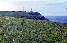
Lighthouse (1980)

Cape (1980)

Krabozavodskoye


See also
Web links
- Kuril Island Network - A volunteer group dedicated to raising awareness of the habitat on the Kurils
- Schikotan on Oceandots ( Memento from December 23, 2010 in the Internet Archive )
- Ainu speaker and activist explains the meaning of the South Kuril island names ( Memento from June 6, 2011 in the Internet Archive )
Individual evidence
- ↑ ア イ ヌ 語 地名 リ ス ト . Hokkaido Prefecture, p. 59 , accessed April 28, 2011 (Japanese).
- ↑ 島 面積 . (PDF; 136 kB) (No longer available online.) Kokudo Chiriin , October 1, 2015, archived from the original on June 15, 2016 ; Retrieved July 30, 2016 (Japanese). Info: The archive link was inserted automatically and has not yet been checked. Please check the original and archive link according to the instructions and then remove this notice.
- ↑ Soviet General Staff Map 1: 200,000. Sheet K-55-03. 1983 edition
- ↑ Itogi Vserossijskoj perepisi naselenija 2010 goda. Tom 1. Čislennostʹ i razmeščenie naselenija (Results of the All-Russian Census 2010. Volume 1. Number and distribution of the population). Tables 5 , pp. 12-209; 11 , pp. 312–979 (download from the website of the Federal Service for State Statistics of the Russian Federation)