
Iturup
| Iturup | ||
|---|---|---|
 |
||
| Waters | Pacific Ocean | |
| Archipelago | Kuril Islands | |
| Geographical location | 45 ° 2 ′ N , 147 ° 37 ′ E | |
|
||
| length | 200 km | |
| width | 27 km | |
| surface | 3 166.64 km² | |
| Highest elevation |
Stokap 1634 m |
|
| Residents | 7500 2.4 inhabitants / km² |
|
| main place | Kurilsk | |
 |
||

Iturup ( Russian Итуруп ; Japanese 択 捉 島 Etorofu -tō ) is an island in the Kuril archipelago. The island is de facto part of Russia , but is claimed by Japan as part of the sub-prefecture of Nemuro , Hokkaidō .
The name comes from the Ainu language , probably from etu-oro-op ( エ ト ゥ オ ロ オ ㇷ ゚ ) for "place with the cape" or etu-or-op ( エ ト ゥ オ ㇿ オ ㇷ ゚ ) for "person / object with nasal water", which is supposed to refer to the fact that there used to be a stone here that looked like a person with a runny nose.
geography
Iturup is northeast of Hokkaidō , near the southern end of the Kuril Islands. With an area of 3,166.64 km², it is by far the largest Kuril island. Iturup is about 200 km long, with a width of 7 to 27 km.
The most important settlement on the island is the city of Kurilsk with about 2,000 inhabitants. A total of around 7500 people live on Iturup (as of 2003). The island has an airport ( IATA airport code : BVV, ICAO code UHSB).
History and politics
Iturup was originally inhabited by Ainu . Russian settlers came to the island in the late 18th century. In 1800 a Japanese garrison was stationed on Iturup. The island was used by Japan as a place of exile for political prisoners and convicts.
In 1855 the island became Japanese territory through the Treaty of Shimoda . In 1945 Iturup was occupied by Soviet troops . Since 1946 the island has belonged to Russian national territory according to the Soviet and since 1991 Russian view. Belonging to the Southern Kuril Islands, the island is the subject of the Kuril conflict : sovereignty over Iturup is claimed by Japan.
A passenger ship, the Etopirika , was built in 2012 especially for mutual visa-free visits by Russian islanders and Japanese citizens .
Volcanoes on Iturup
gallery

Iturup, 1981
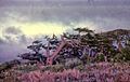
Trees under constant wind, 1981

Kurilsk, local administration building, 1981
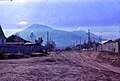
Kurilsk, 1981


Web links
Individual evidence
- ↑ ア イ ヌ 語 地名 リ ス ト . (PDF) Hokkaido Prefecture, p. 19 , accessed April 28, 2011 (Japanese).
- ↑ 島 面積 . (PDF; 136 kB) (No longer available online.) Kokudo Chiriin , October 1, 2015, archived from the original on June 15, 2016 ; Retrieved July 30, 2016 (Japanese). Info: The archive link was inserted automatically and has not yet been checked. Please check the original and archive link according to the instructions and then remove this notice.
- ↑ Новое судно для безвизовых поездок совершает технический рейс по Курильским островам (new ship for visa-free trips on a test trip )
- ↑ Японский министр восхитился экономическими успехами Южных Курил (Japanese minister enthusiastic about the economic success of the Southern Kuril Islands) (Russian)