Raikoke
| Raikoke | ||
|---|---|---|
| Landsat image by Raikoke | ||
| Waters | Pacific Ocean | |
| Archipelago | Kuril Islands | |
| Geographical location | 48 ° 17 '30 " N , 153 ° 14' 30" E | |
|
|
||
| length | 2.5 km | |
| surface | 4.6 km² | |
| Highest elevation | Raikoke 551 m |
|
| Residents | uninhabited | |
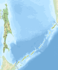
Raikoke ( Russian Остров Райкоке ; Japanese 雷公 計 島 , Raikoke-tō ) is a small uninhabited volcanic island in the central area of the Kuril Islands . It is located about 20 kilometers north of the island of Matua and administratively belongs to the Russian Oblast Sakhalin .
Raikoke is an approximately round island with a diameter of 2.5 kilometers and an area of 4.6 km². It is formed by an active stratovolcano of the same name, which rises steeply from the ocean to a height of 551 meters. The volcanic crater has a depth of 200 meters with a diameter of 700 meters. In a magnitude four eruption on the volcanic explosion index (VEI) in 1778, 15 people were killed by volcanic bombs . The upper third of the volcano is said to have been destroyed in the eruption. The outbreak of 1924 was also magnitude four. On the morning of June 22, 2019, there was a Plinian eruption with a 17 kilometer high ash cloud .
The island is home to one of the five colonies of the Steller sea lion ( Eumetopias jubatus ) and one of the largest populations of the fulmar ( Fulmarus glacialis ) within the Kuril Islands .
literature
- I. Sonn, A. Kostjanoi: Okhotskoye more: enziklopedija . Meschdunarodnyje otnoshenija, Moscow 2009, p. 146. ISBN 978-5-7133-1354-8 (Russian)
Web links
- Raikoke in the Global Volcanism Program of the Smithsonian Institution (English)
- Raikoke on oceandots.com ( Memento from December 23, 2010 in the Internet Archive )
Individual evidence
- ^ Entry in The Significant Volcanic Eruption Database of NOAA (English, accessed on March 25, 2013).
- ↑ Volcanic eruption from above . In: Spectrum of Science . No. 9.19 , September 2019, p. 6th f .
- ↑ Raikoke Erupts. In: earthobservatory.nasa.gov. June 22, 2019, accessed on August 17, 2019 .

