Urup (island)
| Urup | ||
|---|---|---|
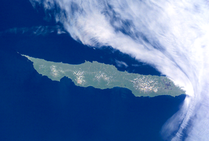
| Satellite image of the island | ||
| Waters | Pacific Ocean | |
| Archipelago | Kuril Islands | |
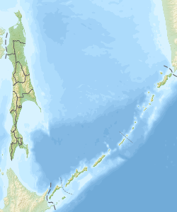
| Geographical location | 45 ° 56 ' N , 150 ° 2' E | |
|
|
||
| surface | 1 430 km² | |
| Highest elevation |
Vysokaya 1426 m |
|
| Residents | uninhabited | |
Urup ( Russian : Уруп; Japanese : 得 撫 島 , Uruppu -tō ) is an island in the Kuril archipelago. The island belongs to Russia .
geography
Urup is located northeast of Hokkaidō , about the latitude of the southern tip of Sakhalin . The island has an area of 1,430 km².
Its highest point is Mount Vysokaya at 1,426 meters . A number of mountain ranges that are fused together at the base are of volcanic origin; of the approximately 25 volcanoes , two are still active: the Tresubez and the Berga .
History and politics
Urup was originally inhabited by Ainu . In the 18th century, Russian traders and hunters came to the island, which led to conflicts with the Ainu in 1772. In 1801 the Japanese government declared Urup to be Japanese territory.
In 1855 the island became Russian territory through the Treaty of Shimoda . In 1875, Urup was re-incorporated into Japanese territory by the Treaty of Saint Petersburg . In 1945, like all other Kuril Islands, Urup was occupied by Soviet troops and has belonged to Soviet territory since 1946 and Russian territory since 1991. Japan gave up all claims to the island in the 1951 peace treaty of San Francisco .

