Atsonupuri
| Atsonupuri | ||
|---|---|---|
|
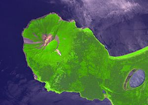
Satellite image of the Atsonupuri (2007) |
||
| height | 1206 m | |
| location | Sakhalin Oblast , Russia | |
| Mountains | Iturup Island , Kuril Islands | |
| Coordinates | 44 ° 48 '25 " N , 147 ° 7' 40" E | |
|
|
||
| Type | Stratovolcano | |
| Last eruption | 1932 | |
The conical volcano Atsonupuri ( Russian Атсонупури , Japanese 阿登佐岳 , Atosanuburi ) forms the peninsula of the same name on the southwest coast of the Kuril island of Iturup . The caldera with a diameter of two kilometers is surmounted by an ash cone that reaches a height of 1206 meters. Strombolian eruptions have been predominant in the history of the volcano and some lava flows have been formed. Historical records show two eruptions in September 1812 and 1932.
Web links
- Atsonupuri in the Global Volcanism Program of the Smithsonian Institution (English)

